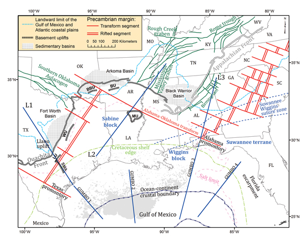
Figure 1.
Tectonic map of the southern U.S. continental margin. Northern boundary of the Gulf of Mexico basin is represented by the Cretaceous shelf edge, adapted from Harry and Londono (2004). Locations of the GUMBO lines and the limit of oceanic crust in the Gulf of Mexico are from Christeson et al. (2014). Location of basinward salt limit is from Hudec et al. (2013). Louann salt province in the Gulf of Mexico, denoted by gray shading, is from Diegel et al. (1995). Locations of the Precambrian rift-transform margin, and other geologic structures and terranes, were derived from Thomas (1991, 2011). MU—Monroe Uplift; BU—Benton Uplift; BBU—Broken Bow Uplift; LU—Luling Uplift; WU—Waco Uplift; SMA—San Marcos Arch. L1 (onshore extension of GUMBO 1), L2, and L3 (onshore extension of GUMBO 3) are locations of cross-sectional profiles examined in Figures 4 and DR2 [see text footnote 1]. AL—Alabama; AR—Arkansas; LA—Louisiana; FL—Florida; GA—Georgia; KY—Kentucky; MO—Missouri; MS—Mississippi; NC—North Carolina; OK—Oklahoma; SC—South Carolina; TN—Tennessee; TX—Texas; VA—Virginia; WV—West Virginia.