
Full Text View
Volume 27 Issue 9 (September 2017)
GSA Today
![]()
Article, pp. 58–59 | Abstract | PDF (3.1MB)
 |
| Table of Contents |
|---|
| Search GoogleScholar Search GSA Today |
GROUNDWORK:
A New Subsidence Map for Coastal Louisiana
Department of Earth and Environmental Sciences, Tulane University, New Orleans, Louisiana 70118-5698, USA
Department of Earth and Environmental Sciences, Tulane University, New Orleans, Louisiana 70118-5698, USA, and Center for Integrative Geosciences, University of Connecticut, Storrs, Connecticut 06269, USA
Coastal Louisiana has experienced catastrophic rates of wetland loss over the past century, equivalent in area to the state of Delaware. Land subsidence in the absence of rapid accretion is one of the key drivers of wetland loss. Accurate subsidence data should therefore form the basis for estimates of and adaptations to Louisiana’s future. Recently, Jankowski et al. (2017) determined subsidence rates at 274 sites along the Louisiana coast. Based on these data we present a new subsidence map and calculate that, on average, coastal Louisiana is subsiding at 9 ± 1 mm yr−1.
Manuscript received 23 Mar. 2017; Revised manuscript received 15 May 2017; Manuscript accepted 16 May 2017; Posted online 14 June 2017
10.1130/GSATG337GW.1
©2017, The Geological Society of America.
Coastal Subsidence
Low-elevation coastal zones (LECZs) are among the most vulnerable landscapes within the context of climate-driven accelerated sea-level rise, often exacerbated by other human impacts as well as high subsidence rates. Predictions of rates of relative sea-level rise (RSLR) in such settings depend to a considerable extent on our ability to monitor present-day subsidence rates—including their spatial pattern—at the land surface. Obtaining such data is challenging; space-based techniques (e.g., InSAR) struggle in non-urbanized landscapes and to date only few of such studies have provided useful results (e.g., Strozzi et al., 2013). Here we combine recently published subsidence data, collected by different yet complementary methods, to produce a novel subsidence map for coastal Louisiana, one of the world’s most vulnerable LECZs.
While a variety of factors have contributed to Louisiana’s wetland loss problem, the fundamental culprit is the isolation of the sediment-delivery system (the Mississippi River) from its delta plain and the adjacent coastal zone due to the construction of flood-protection levees. As a result, the majority of the sediment carried by this system is funneled into the deep waters of the Gulf of Mexico, rather than offsetting the naturally occurring high subsidence rates. A landmark study (Blum and Roberts, 2009) has shown that this problem is likely to worsen in the future due to limited sediment loads and accelerated sea-level rise.
Subsidence Data
Tide gauges are frequently used to obtain records of RLSR. However, tide gauges in coastal Louisiana, and likely many other LECZs, have major limitations because they typically measure RSLR with respect to benchmarks anchored tens of meters below the land surface. Subsidence rates are highest in the uppermost 5–10 m, but the average depth of the benchmarks associated with National Oceanic and Atmospheric Administration (NOAA) tide gauges in coastal Louisiana (n = 31) is ~23 m. Tide gauges therefore do not capture the component that accounts for 60%–85% of the total subsidence as observed at the land surface (Jankowski et al., 2017).
Our recent work (Jankowski et al., 2017) offers a novel approach to determining total subsidence rates at 274 sites along the Louisiana coast, based on data collected through the Coastwide Reference Monitoring System (CRMS) program. The centerpiece of this analysis consists of rod surface-elevation–marker horizon records, 6–10 years long, enabling us to calculate present-day shallow subsidence rates (i.e., shallow compaction) by subtracting the rate of surface-elevation change from the vertical accretion rate at each site (Cahoon, 2015). Recently published GPS time series (Karegar et al., 2015) complement this information; because these GPS stations (n = 13) are typically anchored >15 m below the land surface, they capture the “deep” subsidence component that includes glacial and sedimentary isostatic adjustment (Wolstencroft et al., 2014) plus compaction and faulting in deeper strata.
A New Subsidence Map
Our subsidence map (Fig. 1) shows a spatially continuous pattern of subsidence rates as recorded at the land surface, based on the sum of the two data sources discussed above. While spatial variability between our discrete monitoring sites is high, the map shows that the expected average subsidence rate is relatively uniform across coastal Louisiana, with a mean rate of 9 mm yr−1 and a standard error of the mean of 1 mm yr−1. It should be noted, however, that uncertainties at individual monitoring sites are significantly higher, and we therefore stress that both model (Fig. 1C) and data (Fig. 1D) uncertainties should be taken into account when estimating subsidence rates at specific localities, including those that coincide with CRMS sites. The map predicts slightly higher than average subsidence rates in the eastern Chenier Plain, the Atchafalaya and Wax Lake Deltas, and along the Mississippi River downstream of New Orleans. The lowest rates are found in the western portion of the Chenier Plain, the region with the lowest vertical accretion rates (Jankowski et al., 2017). These two findings are in all likelihood related; shallow compaction rates are known to be highly sensitive to overburden loading. The high subsidence rates in coastal Louisiana likely mostly reflect natural processes that have operated over the past millennia. Despite the associated high rates of RSLR, the abundant sediment supplied by the Mississippi River allowed its delta to evolve into one of the world’s largest.
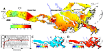 Figure 1
(A) Subsidence map for coastal Louisiana based on geostatistical interpolation (kriging) of 274 observations (black dots) of land-surface subsidence rates over the past 6–10 years. Areas in white and gray are agricultural and urban, respectively, and located outside of the wetlands. (B) Semivariogram of the data using 100 draws from different kriging options (gray), the data mean (black), and the kriging model (red). (C) Uncertainty (standard deviation) of the kriging estimate. Black squares show GPS stations. (D) Uncertainty (standard deviation) of the underlying data. Black squares show National Oceanic and Atmospheric Administration (NOAA) tide gauges. Note that the subsidence map can easily be converted into a relative sea-level rise map by adding the climate-driven sea-level component.
The new subsidence map should be considered a first step; substantial efforts are needed to refine this analysis. For example, our findings are not relevant for embanked urban settings with artificial drainage and localized groundwater extraction (Jones et al., 2016), most notably the New Orleans metropolitan area, as well as the agricultural land that occupies well-drained alluvial ridges. We omitted these areas from our subsidence map. Other caveats include the possibility of underestimated rates in the birdfoot delta around the mouth of the Mississippi River, which is known to exhibit anomalously high subsidence rates (Fisk et al., 1954). We also cannot rule out that active growth faults and hydrocarbon extraction may locally cause higher rates not captured by the GPS stations.
Our newly calculated present-day subsidence rates are considerably higher than what has been reported by recent studies that relied partly or entirely on tide gauges and that inferred rates of 1–6 mm yr−1 for the past few decades (Kolker et al., 2011; Karegar et al., 2015). As a result, “worst case scenarios” with subsidence rates of 8–10 mm yr−1 that have been used in predictions for the Mississippi Delta throughout the 21st century (Blum and Roberts, 2009; Kim et al., 2009) are in fact reflecting the conditions that exist in coastal Louisiana today. Perhaps worst case scenarios should be considered the new normal in other LECZs worldwide as well.
Acknowledgments
This study would not have been possible without funding from the Coastal Wetland Planning, Protection, and Restoration Act (CWPPRA) Program and the State of Louisiana to support the Coastwide Reference Monitoring System (CRMS). The Coastal Protection and Restoration Authority of Louisiana and the United States Geological Survey jointly implement the CRMS Program on behalf of CWPPRA. Funding for this study was also provided by the National Science Foundation (EAR-1349311), the National Institute for Climatic Change Research Coastal Center of the Department of Energy, and The Water Institute of the Gulf. We would like to thank Marc Bierkens for his advice on spatial interpolation. We appreciate the constructive comments from Luigi Tosi and an anonymous reviewer.
References Cited
- Blum, M.D., and Roberts, H.H., 2009, Drowning of the Mississippi Delta due to insufficient sediment supply and global sea-level rise: Nature Geoscience, v. 2, p. 488–491, doi:10.1038/ngeo553.
- Cahoon, D.R., 2015, Estimating relative sea-level rise and submergence potential at a coastal wetland: Estuaries and Coasts, v. 38, p. 1077–1084, doi:10.1007/s12237-014-9872-8.
- Fisk, H.N., Kolb, C.R., McFarlan, E., and Wilbert, L.J., 1954, Sedimentary framework of the modern Mississippi delta: Journal of Sedimentary Petrology, v. 24, p. 76–99, doi:10.1306/D4269661-2B26-11D7-8648000102C1865D.
- Jankowski, K.L., Törnqvist, T.E., and Fernandes, A.M., 2017, Vulnerability of Louisiana’s coastal wetlands to present-day rates of relative sea-level rise: Nature Communications, v. 8, 14792, doi:10.1038/ncomms14792.
- Jones, C.E., An, K., Blom, R.G., Kent, J.D., Ivins, E.R., and Bekaert, D., 2016, Anthropogenic and geologic influences on subsidence in the vicinity of New Orleans, Louisiana: Journal of Geophysical Research, Solid Earth, v. 121, p. 3867–3887, doi:10.1002/2015JB012636.
- Karegar, M.A., Dixon, T.H., and Malservisi, R., 2015, A three-dimensional surface velocity field for the Mississippi Delta: Implications for coastal restoration and flood potential: Geology, v. 43, p. 519–522, doi:10.1130/G36598.1.
- Kim, W., Mohrig, D., Twilley, R., Paola, C., and Parker, G., 2009, Is it feasible to build new land in the Mississippi River Delta?: Eos, v. 90, p. 373–374, doi:10.1029/2009EO420001.
- Kolker, A.S., Allison, M.A., and Hameed, S., 2011, An evaluation of subsidence rates and sea-level variability in the northern Gulf of Mexico: Geophysical Research Letters, v. 38, L21404, doi:10.1029/2011GL049458.
- Strozzi, T., Teatini, P., Tosi, L., Wegmüller, U., and Werner, C., 2013, Land subsidence of natural transitional environments by satellite radar interferometry on artificial reflectors: Journal of Geophysical Research, Earth Surface, v. 118, p. 1177–1191, doi:10.1002/jgrf.20082.
- Wolstencroft, M., Shen, Z., Törnqvist, T.E., Milne, G.A., and Kulp, M., 2014, Understanding subsidence in the Mississippi Delta region due to sediment, ice, and ocean loading: Insights from geophysical modeling: Journal of Geophysical Research, Solid Earth, v. 119, p. 3838–3856, doi:10.1002/2013JB010928.