
Full Text View
Volume 26 Issue 12 (December 2016)
GSA Today
![]()
Article, pp. 4-11 | Abstract | PDF (4.8MB)
A Novel Plate Tectonic Scenario for the Genesis and Sealing of Some Major Mesozoic Oil Fields
| Table of Contents |
|---|
|
Search GoogleScholar for
Search GSA Today |
Abstract
Recent research reveals evidence of a major event of global plate motion during the Jurassic, with a magnitude and tempo hitherto not fully appreciated. Yet, its legacy persists today as the potent Jurassic source-reservoir-seal oil systems in the Persian Gulf region. We suggest that these formed as a consequence of a sweeping tectonic movement whereby Arabia drifted rapidly from the oil-forming Intertropical Convergence Zone along the equator to the arid tropics of the southern hemisphere with rapid deposition of relatively uncemented carbonate reservoirs and anhydrite seals, all during as little as 15 m.y. in the Late Jurassic. The Ghawar supergiant oil field of Saudi Arabia was one of the results. Rapid latitudinal change may have influenced the development of some source-reservoir-seal oil systems elsewhere as well.
*E-mail: giovanni.muttoni1@unimi.it
Manuscript received 25 February 2016; revised manuscript received 6 June 2016; accepted 10 June 2016
doi: 10.1130/GSATG289A.1
Introduction
Ghawar is the world’s largest oil field, a supergiant that accounts for ~60% of Saudi Arabia’s crude production (Al-Anazi, 2007). The source rocks at Ghawar are marine muds and carbonates of the Tuwaiq Mountain and Hanifa formations (Alsharhan and Nairn, 1997) deposited in the Callovian-Oxfordian stages of the Late Jurassic (Al-Husseini, 2009) between 166 and 157 Ma (time scale of Cohen et al., 2013). The reservoirs are located in overlying bioclastic limestones of the Kimmeridgian (Late Jurassic; 157–151 Ma) Arab Formation that are sealed by anhydrites of the Tithonian (Late Jurassic; 152–145 Ma) Hith Formation (Alsharhan and Nairn, 1997; Al-Husseini, 2009).
This closely packed layercake stratigraphy with source and reservoir rocks sealed upsection with anhydrites makes Ghawar and similar supergiant oil fields of the Persian Gulf a dreamland for oil exploitation essentially because it minimizes the variables associated with oil maturation and migration that are by far the most difficult to forecast in oil assessment protocols. At the same time, these hydrocarbon provinces constitute a paleogeographic conundrum. Organic matter that eventually transforms into oil and gas with burial and maturation can originate in abundance in sedimentary basins along the Intertropical Convergence Zone (ITCZ), which straddles about ±5° from the equator (Manabe and Bryan, 1985; Kent and Muttoni, 2013; McGee et al., 2014) due to high levels of nutrients upwelled from deep waters or in run-off from adjoining continents onto shelf areas. And indeed, protracted residence along the equator is the commonly accepted explanation for the origin of the shelf-facies Jurassic oil in the Persian Gulf (Al-Awwad and Collins, 2013). However, carbonate sands for a reservoir and especially an anhydritic seal are more likely formed at tropical latitudes (~5–30°) where evaporation exceeds precipitation even under highly variable atmospheric pCO2 levels (Manabe and Bryan, 1985). So it seems that to form a winning temporal sequence of source-reservoir-seal rock units, Arabia (= Persian Gulf region) needs to cross the ITCZ (deposition of Callovian-Oxfordian source rocks) and into the tropical arid belt (deposition of Kimmeridgian reservoir and especially Tithonian seal) in less than 15 m.y. within the Late Jurassic.
Recent research shows the existence of a major event of global plate (or even whole-mantle) motion during the Jurassic that was hitherto unknown to the earth science community and can be referred to as the Jurassic polar shift (Kent and Irving, 2010; Muttoni et al., 2013; Kent et al., 2015). When the Jurassic polar shift is taken into account to describe global paleogeography, the rapid trans-zonal plate motion that produced the source-reservoir-seal sequence at Ghawar and elsewhere in the world can be adequately explained.
Jurassic Polar Shift
The recent discovery of the Jurassic polar shift was made from paleomagnetic studies that provide a means to track the motion of tectonic plates relative to Earth’s spin axis. Under favorable conditions, the remanent magnetization of rocks records ancient geomagnetic field directions, which when averaged over several thousands of years, closely correspond to those of a geocentric axial dipole (GAD). According to the GAD hypothesis, paleomagnetic directions of similar age from localities on a rigid tectonic plate should give the same paleomagnetic pole and hence the location of that plate with respect to the geographic axis or, equivalently, parallels of latitude. A temporal sequence of paleopoles or an apparent polar wander (APW) path is a convenient way to represent the motion of a tectonic plate with respect to the rotation axis (e.g., Creer and Irving, 2012). Relative motions between tectonic plates (usually their continental proxies) are detected by systematic differences in their respective APW paths (e.g., Van der Voo, 1990). It is also possible that Earth’s entire crust and mantle rotated with respect to the spin axis, a still poorly understood phenomenon referred to as True Polar Wander (TPW) (e.g., Goldreich and Toomre, 1969). In either case—APW or TPW—the included continents experience an effective rotation about a Euler pole that involves a systematic change in latitude according to the GAD hypothesis.
The Jurassic polar shift largely derives from the recognition of a distinct set of paleomagnetic poles deemed reliable from three different continents and centered on ca. 145 Ma (Kent and Irving, 2010). The mean location of these three poles plots as the apex or cusp of a novel APW path when reconstructed to common coordinates using standard relative plate reconstructions. The APW path was constructed from published paleomagnetic poles from well-dated magmatic units and only those sedimentary units corrected for inclination flattening (Tauxe and Kent, 2004; Kent and Tauxe, 2005). The poles range in age from 230 to 50 Ma (Triassic to Eocene) from all the major continents that could be closely linked by plate circuits (see Fig. 4 in Kent and Irving, 2010). The resulting global composite APW path shows the presence of a previously undetected yet major polar shift of ~30° separating the 160 Ma (Oxfordian, Late Jurassic) mean paleopole from the mean cusp paleopole at 145 Ma, close in age to the Jurassic-Cretaceous boundary.
Whether the 1–2°/m.y. of Jurassic polar shift represents an episode of fast whole mantle rotation (TPW) or only rotation of the reconstructed continental lithosphere (APW), the main continents in either case rotated in unison clockwise by up to ~30° about a Euler pole centered on the equator (Fig. 1; Kent et al., 2015). As a result, Arabia drifted southward from straddling the ITCZ at ca. 160 Ma to plunging at up to 1–2°/m.y. (up to ~20 cm/yr) into the tropical arid belt of the southern hemisphere by 145 Ma. The main continents then rotated in unison anticlockwise about virtually the same Euler pole so that Arabia drifted northward back across the ITCZ and into the boreal arid belt by 120 Ma. Such a rapid polar shift and the backtrack at the 145 Ma cusp are not precluded either by any speed limit on plates (Meert et al., 1993) coupled with their negligible momentum (Forsyth and Uyeda, 1975) nor by models of whole-mantle motions for TPW (Tsai and Stevenson, 2007; Greff-Lefftz and Besse, 2014).
The critical 145 Ma apex paleopole of Kent and Irving (2010) is based on an average of three individual entries from radiometrically dated igneous units:
- The Ithaca kimberlite paleopole from New York State in North America, based on high-temperature magnetic component directions bearing dual (normal and reverse) polarity from seven sites sampled in dikes intruding flat-lying Devonian platform carbonates, giving a positive baked contact test and with a geometry that precludes significant post-emplacement tectonic disturbances (Van Fossen and Kent, 1993); the Ithaca kimberlites are now provided with a U/Pb perovskite date of 146.4 ± 1.4 Ma (Kent et al., 2015).
- The ca. 145 Ma combined Bumbeni-Swartruggens paleopole from South Africa, comprised of the Bumbeni syenite complex dated with Ar/Ar at 145.8 ± 1.3 Ma, which yielded bipolar paleomagnetic results from four sites, and the kimberlite fissures at Swartruggens dated with K-Ar and Ar/Ar to a mean of 142 ± 4 Ma, which also yielded bipolar paleomagnetic results from two sites (Main and Male kimberlites; Hargraves et al., 1997, and references therein).
- The Hinlopenstretet paleopole from Svalbard, based on high-temperature magnetic component directions from 17 sites sampled in dikes dated with K-Ar to a mean age of 144 ± 5 Ma (Halvorsen, 1989).
The Bumbeni-Swartruggens and Hinlopenstretet paleopoles, when transferred into North American coordinates using rotation parameters to account for seafloor spreading in the Atlantic, fall at only 6° and 8°, respectively, from the cratonic Ithaca paleopole; this congruence of results from three continents allows erecting a mean paleopole at ca. 145 Ma with a 95% confidence circle (A95) of 9° (Kent and Irving, 2010).
The position of the ca. 145 Ma apex paleopole is confirmed by entirely independent data from magneto-biostratigraphically dated sections from Adria—the African promontory. These data have been successfully correlated to the marine magnetic anomaly M-sequence and corrected for sedimentary inclination shallowing (Muttoni et al., 2013). Two mean paleomagnetic poles for Adria-Africa are of particular interest for our discussion: a mean paleopole based on three stratigraphic sections straddling magnetic polarity chron CM22 at 151 ± 1 Ma in the Early Tithonian, and a mean paleopole at 145 ± 2 Ma in the mid-Tithonian–Berriasian (across the Jurassic-Cretaceous boundary) based on six sections altogether from polarity chron CM17 to CM21 (Muttoni et al., 2013). These two paleopoles at ca. 151 and ca. 145 Ma lie at only 1° and 7°, respectively, from the ca. 145 Ma paleopole of Kent and Irving (2010) rotated into African coordinates (Muttoni et al., 2013). Finally, a mean kimberlite paleopole from Ontario, Canada, dated with state-of-the-art U/Pb on perovskite to 156 ± 1.6 Ma, neatly plots in the middle of the Jurassic polar shift and provides additional independent support for it (Kent et al., 2015).
Acknowledging the limitations of our small subset of nonetheless well-dated and inclination flattening-free Late Jurassic paleopoles from stable regions of different plates (North America, Europe, Africa), the overall coherent progression they depict once restored to a common reference frame, confirmed by magneto-biostratigraphically calibrated data from Adria, is taken as evidence that the Jurassic shift constitutes a real feature of polar wander occurring between 160 and 145 Ma (Kent and Irving, 2010; Muttoni et al., 2013; see also Muttoni et al., 2005). This feature is largely underestimated in other APW paths from the literature essentially because of the inclusion of paleopoles poorly constrained in age and inclination flattening degree.
Coupled Oil Source-Seal Formation during the Jurassic Polar Shift
We computed a paleolatitude curve for Ghawar (Fig. 2, white circles with vertical error bars) using an APW path incorporating the Jurassic polar shift using the aforementioned paleopoles from Kent and Irving (2010) and Kent et al. (2015) (Table 1). According to this curve, Ghawar was located well within the ITCZ during virtually the entire Early, Middle and early-Late Jurassic, but by 145 Ma, it rapidly drifted to ~20° in the southern hemisphere. In other words, Ghawar traveled within 15 million years from the oil-forming productive ITCZ to the seal-forming arid tropics of the southern hemisphere.
|
Paleocontinental reconstructions bracketing the Jurassic polar shift: in left panel, reconstructions at 160 Ma (light gray shading) and 145 Ma (dark gray shading); in right panel, reconstructions at 145 Ma (light gray shading; same as in left panel) and 120 Ma (dark gray shading). The Euler pole (E) for rotating the continental assemblage clockwise from 160 to 145 Ma and counterclockwise from 145 to 120 Ma is located on the equator in the vicinity of the Bight of Benin of western Africa. The stars connected by arrows indicate the sites discussed in the text: Ghawar in Saudi Arabia, Neuqén in Argentina, and the Gulf of Mexico (GoM). Green latitudinal belts represent the Intertropical Convergence Zone (ITCZ) within ±5° equator and the temperate humid belts, whereas the arid belts encompass the tropics up to ±30° latitude (modified from Kent et al., 2015). |
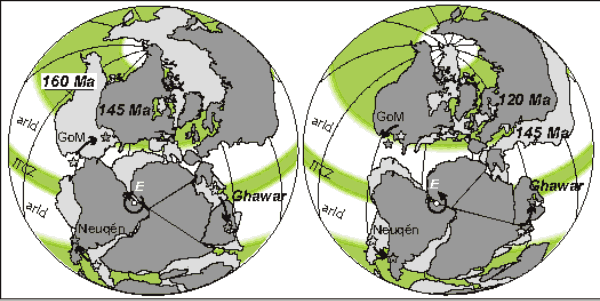 Figure 1
|
Composite APW path used to calculate paleolatitues at Ghawar. |
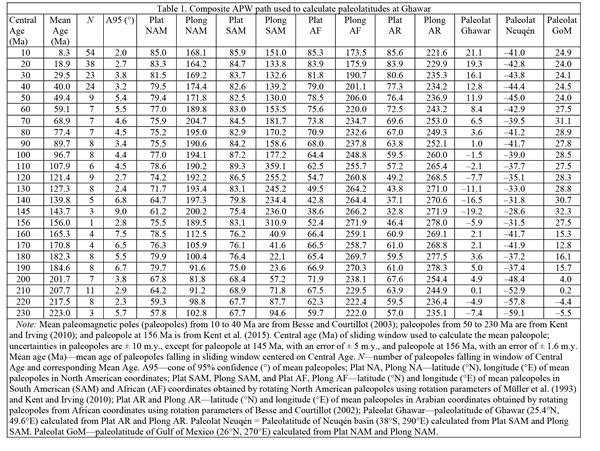 Table 1
This drift history neatly explains the Late Jurassic stratigraphy of the area. The Callovian–Oxfordian (166–157 Ma) Tuwaiq Mountain and Hanifa formations (Al-Husseini, 2009), which represent the main source rocks of Jurassic oil at Ghawar (Alsharhan and Nairn, 1997) were deposited when eastern Saudi Arabia resided on the ITCZ while the overlying Tithonian (152–145 Ma) Hith Formation anhydrites (Al-Husseini, 2009), representing the main seal cap (Alsharhan and Nairn, 1997), were deposited as Saudi Arabia rapidly drifted to the arid southern tropics (Fig. 2). This rapid source-to-seal succession allowed the actual reservoirs to be located in the intervening porous bioclastic limestones of the Arab Formation (Daraei et al., 2014). Similar scenarios can be envisaged for other correlative systems involving the Tuwaiq-Hanifa sources and Hith anhydrite seal in neighboring Bahrain, Quatar, and the UAE (Alsharhan and Nairn, 1997; Alsharhan and Magara, 1994; Al-Suwaidi et al., 2000), whereas more to the north in central Iran, sedimentation switched from mid-latitude coal-bearing to tropical evaporitic during the Jurassic polar shift (Mattei et al., 2014).
The ensuing progression of paleolatitudes after the Jurassic polar shift that culminated at the 145 Ma cusp shows that Ghawar drifted back, albeit more slowly, across the ITCZ from the arid tropics of the southern hemisphere to the arid tropics of the northern hemisphere during the Cretaceous–Paleogene (Fig. 2). This provided a second time window in the Cretaceous for the formation of oil that is indeed also widespread in the Persian Gulf region. For example, most of Iran’s oil reserves situated in the Persian Gulf (within ~400 km from Ghawar) are also sourced in Cretaceous rocks (e.g., Albian Kazhdumi Formation, Cenomanian Ahmadi Member of the Sarvak Formation, Late Cretaceous Gurpi Formation; Bordenave and Burwood, 1995; Mashhadi and Rabbani, 2015) that formed at or close to the ITCZ and were sealed by the Miocene Gachsaran evaporites (Soleimani and Bahadori, 2015).
At approximately similar distances from the equatorial Euler pole but on the other side of Gondwana, the oil-producing Neuqén Basin of Argentina provides an example of a source-reservoir-seal plate-motion stratigraphy involving transits across the boundary between the (austral) temperate humid belt and the tropical arid belt (Fig. 1). There, Early–Middle Jurassic and latest Jurassic–earliest Cretaceous marine shale source rocks (Los Molles and Vaca Muerta formations) are separated by an intervening evaporitic unit (Auquilco Formation) of Oxfordian–Kimmeridgian (Late Jurassic) age, whereas the overlying Cretaceous rocks are mainly continental (e.g., Howell et al., 2005; Palma et al., 2007; Boyer et al., 2011). A paleolatitude curve calculated for the Neuqén Basin (Fig. 3, upper panel; Table 1) shows that the Neuqén Basin dwelled at paleolatitudes higher than ~35°S (temperate humid belt) during practically the entire Mesozoic and Cenozoic except for a single northward incursion to ~30°S at 145 Ma, the culminating cusp of the Jurassic polar shift. This brief incursion toward a presumably more arid environment broadly coincided (within the error resolution of the available biostratigraphic dating of the Neuqén Basin sequence) with deposition of the Auquilco evaporites that seal the underlying Los Molles marine shales (Fig. 3, upper panel).
|
The paleolatitudinal evolution curve (white circles) of Ghawar (25.4°N, 49.6°E) in the Persian Gulf of Saudi Arabia calculated from the inclination flattening-free apparent polar wander (APW) path of Table 1 (in Arabian coordinates) that incorporates the Jurassic polar shift; errors in age (not shown to enhance visual clarity of diagram) are ± 10 m.y. except for paleolatitudes at 145 and 156 Ma with errors of ± 5 and ± 1.6 m.y., respectively; errors in paleolatitude (shown as vertical bars) are equal to ± A95 (cone of 95% confidence of mean paleomagnetic pole). The black arrow highlights the latitudinal drift associated with the Jurassic polar shift. Paleolatitudes computed for Ghawar using the Torsvik et al. (2012) APW path are also reported for comparison (black triangles, with error bars at 180, 170, 160, 150 Ma). The names of main source and seal rock formations/members discussed in the text are also reported (e.g., Hanifa, Hith) together with the temporal distribution of main Oceanic Anoxic Events: To—“Posidonienschiefer” (Toarcian); W—“Weissert” (Valanginian–Hauterivian); 1a—“Selli” (Early Aptian); 1b—“Paquier” (Late Aptian–Early Albian); 1c—“Toolebuc” (Late Albian); 1d—“Breistroffer” (Late Albian); 2—“Bonarelli” (Cenomanian–Turonian boundary); and 3 (Coniacian–Santonian) (Cronin, 2010). CFGF’13—time scale of Cohen et al. (2013); GO’04—time scale of Gradstein and Ogg (2004). ITCZ—Intertropical Convergence Zone; He—Hettangian; Si—Sinemurian; P—Pliensbachian; T—Toarcian; Aa—Aalenian; Bj—Bajocian; Bt—Bathonian; Cal—Callovian; O—Oxfordian; K—Kimmeridgian; Ti—Tithonian; Be—Berriasian; V—Valanginian; Ha—Hauterivian; Ba—Barremian; Ap—Aptian; Al—Albian; Ce—Cenomanian; Tu—Turonian; Co—Coniacian; Sa—Santonian; Cam—Campanian; M—Maastrichtian; Pa—Paleocene; E—Eocene; Ol—Oligocene; Mi—Miocene; PP—Pliocene–Pleistocene. |
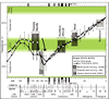 Figure 2
When our plate-motion stratigraphy operates in reverse mode—the transit occurring from the arid tropics into productive equatorial or mid-latitude humid belts—the resulting layercake sequence does not conspire positively for sealing oil. In these cases, the development of diapirs from the underlying evaporites and/or other tectonic or salt-related features can, however, provide traps for oil. A prominent example is the Gulf of Mexico (Fig. 1) where the Louann Salt, an important source of oil-trapping salt domes in the Gulf region (Mancini et al., 2008), formed as the Gulf dwelled at arid tropical latitudes of 10–15°N in the Middle Jurassic (Fig. 3, lower panel; Table 1). As the Gulf drifted to 30–32°N into the presumed temperate belt during the Jurassic polar shift, the Late Jurassic Smackover and Bossier source rocks were deposited (Mancini et al., 2008). Subsequently, during the Cretacous, the Gulf was stationed at around 30°N and was the locus of formation of additional source rocks (Pine Island, Moorigsport, Tuscaloosa; Mancini et al., 2008), some of which appear to often coincide with Cretaceous ocean anoxic events (OAEs) (Fig. 3, lower panel). We note, however, that there is a gap in OAEs between the Toarcian and early Aptian, a time interval that includes the Late Jurassic polar shift and the development of the source-reservoir-seal system at Ghawar (Fig. 2).
|
In upper panel, the paleolatitudinal evolution of the Neuqén Basin in Argentina (38°S, 290°E) and in lower panel of the Gulf of Mexico offshore Texas (26°N, 270°E) calculated from the APW path of Table 1 (in South American and North American coordinates, respectively). Errors in age (not shown to enhance visual clarity of diagram) are ±10 m.y. except for paleolatitudes at 145 and 156 Ma with errors of ±5 and ±1.6 m.y., respectively; errors in paleolatitude (shown as vertical bars) are equal to ± A95 (cone of 95% confidence of mean paleomagnetic pole). The black arrows highlight the latitudinal drift associated with the Jurassic polar shift. Included in both diagrams are the paleolatitudes predicted from the Torsvik et al. (2012) APW path for 180–120 Ma (black triangles) with vertical error bar at 150 Ma. The names of main source and seal rock formations discussed in the text are also reported (e.g., Los Molles, Auquilco, Vaca [ = Vaca Muerta], Louann, Smackover). Continental, marine—continental or marine sedimentation. Oceanic Anoxic Events (OAEs): To—“Posidonienschiefer” (Toarcian); W—“Weissert” (Valanginian–Hauterivian); 1a—“Selli” (Early Aptian); 1b—“Paquier” (Late Aptian–Early Albian); 1c—“Toolebuc” (Late Albian); 1d—“Breistroffer” (Late Albian); 2—“Bonarelli” (Cenomanian–Turonian boundary); and 3 (Coniacian–Santonian) (Cronin, 2010). CFGF’13—time scale of Cohen et al. (2013); GO’04—time scale of Gradstein and Ogg (2004). ITCZ—Intertropical Convergence Zone; He—Hettangian; Si—Sinemurian; P—Pliensbachian; T—Toarcian; Aa—Aalenian; Bj—Bajocian; Bt—Bathonian; Cal—Callovian; O—Oxfordian; K—Kimmeridgian; Ti—Tithonian; Be—Berriasian; V—Valanginian; Ha—Hauterivian; Ba—Barremian; Ap—Aptian; Al—Albian; Ce—Cenomanian; Tu—Turonian; Co—Coniacian; Sa—Santonian; Cam—Campanian; M—Maastrichtian; Pa—Paleocene; E—Eocene; Ol—Oligocene; Mi—Miocene; PP—Pliocene–Pleistocene. |
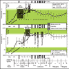 Figure 3
Discussion
The Jurassic polar shift, whether it represented a generalized event of continental drift or a whole mantle rotation, constitutes a novelty of global plate motion. APW paths published before Kent and Irving (2010) do not show the Jurassic polar shift in its full extent, only a very subdued hairpin around the Jurassic–Cretaceous boundary. For example, according to paleolatitudes computed using the widely cited Torsvik et al. (2012) APW path (Fig. 2, black triangles with vertical error bars across critical interval 180–150 Ma), Ghawar was located in the center of the ITCZ only during the Late Triassic and Early Jurassic; a transit from the oil-generating ITCZ to the seal-generating austral tropical arid belt is evident, but according to their APW path, it would have occurred in the Early–Middle Jurassic and therefore cannot readily explain the observed source-to-seal systems of the Persian Gulf. However, soon afterward in the Cretaceous, paleolatitudes from virtually all modern APW paths come into close agreement and can equally explain the Cretaceous source-to-seal oil systems in the Persian Gulf region (Fig. 2).
Torsvik et al. (2012) recognized that the Jurassic “spike” and associated features seen in the Kent and Irving (2010) APW path differ strongly from their and other published APW paths (e.g., Besse and Courtillot, 2002). They attributed the differences as largely an artifact of aliasing from the low number of input poles deemed reliable by Kent and Irving (2010). We believe that the retention of often poorly dated (±10 m.y. or more) or otherwise potentially biased paleomagnetic data, especially of earlier vintage for which, moreover, no direct assessment of sedimentary inclination error is available (e.g., Jura Blue Limestone sediments of Switzerland, Sub-Tatric and Krakow Upland sediments of Poland, Tunisia Upper Jurassic sediments, Rio Grande do Norte dikes of Brazil), is likely to attenuate the full expression of important features of APW, such as the Jurassic polar shift (see Kent and Irving, 2010, for a discussion).
Conclusions
In this paper, we show how APW paths based on stricter acceptance criteria can lead to an interesting reconciliation between paleolatitudes, generalized zonal climate belts, and the generation and sealing of the Late Jurassic Persian Gulf oil. Of course, not all oil formed and was sealed in the plate-motion–mediated manner we describe for Ghawar, as a notable example. Other oil systems like Neuqén and the Gulf of Mexico, where Jurassic latitudinal changes were smaller, may be controlled by other factors operating at more local basin scales (orography, coastal upwelling, high riverine nutrient supply) or more strongly depend on the different levels of details of the climate models adopted (e.g., Manabe and Bryan, 1985; Sellwood and Valdes, 2006; Huber and Caballero, 2011). Nevertheless, relevant aspects of the basic zonal climate model we adopted, which assumes a simple geography and very different pCO2 levels (Manabe and Bryan, 1985), seems to be confirmed by more comprehensive analyses of Hadley circulation showing that since the Last Glacial Maximum, mean ITCZ shifts are likely to be within 1° latitude from the equator (McGee et al., 2014). And local basin controls must still operate in the context of latitudinal-dependent factors that paleomagnetic poles are well-suited to constrain.
We acknowledge that there could exist specific (and thus inevitably rare) combinations of local variables that could explain the occurrence of organic matter-rich deposits at tropical latitudes, where aridity would be normally expected, or marine evaporites on the equator, where precipitation exceeding evaporation is the (zonal) norm, but in general, it is hard to deny that the most potent venues to generate extensive and persistent marine evaporites are the arid tropics (e.g., present day Red Sea, Abu Dhabi) rather than the humid equator. Orography is known to perturb zonal circulation patterns, but considering the wide spatial distribution and tight temporal coupling between source and seal rock formation in the Late Jurassic of the Persian Gulf, one would expect a major orographic perturbation to rise (or disappear) in a few million years, shifting the paradigm from rapid horizontal plate motion, for which we have direct paleomagnetic evidence, to rapid vertical crustal motion, for which there is no evidence at least in the Persian Gulf.
Our plate-motion scenario of the Arabian passive continental margin (where organic matter could be efficiently buried in sediments) crossing the ITCZ of high nutrient availability and organic matter productivity and rapidly drifting into the anhydritic seal-forming tropics seems to explain some of the key factors that contributed to the world’s Jurassic hydrocarbon richness, especially in the Persian Gulf, home of the world’s largest oil field at Ghawar (Alsharhan and Nairn, 1997; Sorkhabi, 2010). Notably, a reduced timing between source and seal formation as predicted by our plate stratigraphy model reduces the uncertainties related to oil maturation and migration relative to timing of trap formation: Oil can migrate virtually any time after organic matter deposition and maturation and still be efficiently trapped by the early-in-place evaporitic seal lying immediately above.
In conclusion, our plate tectonic model for the genesis and sealing of Late Jurassic oil, especially in the Persian Gulf, should be considered a promising first-order model that will require further tests and elaboration by means of finely dated, global plate-motion scenarios. These will in turn be obtained by means of a further improved inventory of well-dated and inclination
flattening-free paleomagnetic data as well as paleoclimate models of paleogeographies cast in the appropriate latitudinal reference frame according to the geocentric axial dipole model.
Acknowledgments
The editor and three anonymous reviewers are thanked for insightful comments on an earlier version of this manuscript. This is Lamont-Doherty Earth Observatory contribution #8049.
References Cited
- Al-Anazi, B.D., 2007, What you know about the Ghawar Oil Field, Saudi Arabia: CSEG Recorder, v. 32, p. 40–43.
- Al-Awwad, S.F., and Collins, L.B., 2013, Carbonate-platform scale correlation of stacked high-frequency sequences in the Arab-D reservoir, Saudi Arabia: Sedimentary Geology, v. 294, p. 205–218, doi: 10.1016/j.sedgeo.2013.05.015.
- Al-Husseini, M., 2009, Update to Late Triassic–Jurassic stratigraphy of Saudi Arabia for the Middle East geologic time scale: GeoArabia, v. 14, p. 145–186.
- Al-Suwaidi, A.S., Taher, A.K., Alsharan, A.S, and Salah, M.G., 2000, Stratigraphy and geochemistry of Upper Jurassic Diyab Formation, Abu Dhabi, UAE: SEPM (Society for Sedimentary Geology), v. 69, p. 249–271.
- Alsharhan, A.S., and Magara, L., 1994, The Jurassic of the Arabian Gulf Basin: Facies, depositional setting and hydrocarbon habitat, in Embry, A.F., ed., Pangea—Global environment and resources: Canadian Society of Petroleum Geologists Memoir 17, p. 397–412.
- Alsharhan, A.S., and Nairn, A.E.M., 1997, Sedimentary basins and petroleum geology of the Middle East: Amsterdam, Elsevier, 942 p.
- Besse, J., and Courtillot, V., 2002, Apparent and True Polar Wander and the geometry of the geomagnetic field over the last 200 Myr: Journal of Geophysical Research, v. 107, doi: 10.1029/2000JB000050.
- Besse, J., and Courtillot, V., 2003, Correction to “Apparent and true polar wander and the geometry of the geomagnetic field over the last 200 Myr”: Journal of Geophysical Research, v. 108, doi: 10.1029/2003JB002684.
- Bordenave, M.L., and Burwood, R., 1995, The Albian Kazhdumi Formation of the Dezful Embayment, Iran: One of the most efficient petroleum generating systems, in Katz, B.J., ed., Petroleum Source Rocks: Berlin, Springer, p. 183–207.
- Boyer, C., Clark, B., Jochen, V., Lewis, R., and Miller, C.K., 2011, Shale gas: A global resource: Oilfield Review, v. 23, no. 3, p. 28–39.
- Channell, J.E.T., Casellato, C., Muttoni, G., and Erba, E., 2010, Magnetostratigraphy, nannofossil stratigraphy and apparent polar wander for Adria-Africa in the Jurassic-Cretaceous boundary interval: Palaeogeography, Palaeoclimatology, Palaeoecology, v. 293, p. 51–75.
- Cohen, K.M., Finney, S.C., Gibbard, P.L., and Fan, J.-X., 2013, The ICS International Chronostratigraphic Chart: Episodes, v. 36, p. 199–204.
- Creer, K., and Irving, E., 2012, Testing continental drift: Constructing the first palaeomagnetic path of polar wander (1954): Earth Sciences History, v. 31, no. 1, p. 111–145, doi: 10.17704/eshi.31.1.t4101011075g8125.
- Cronin, T.M., 2010, Paleoclimates: Understanding Climate Change Past and Present: New York, Columbia University Press, 441 p.
- Daraei, M., Rahimpour-Bonab, H., and Fathi, N., 2014, Factors shaping reservoir architecture in the Jurassic Arab carbonates: A case from the Persian Gulf: Journal of Petroleum Science Engineering, v. 122, p. 187–207, doi: 10.1016/j.petrol.2014.07.010.
- Forsyth, D., and Uyeda, S., 1975, On the relative importance of the driving forces of plate motion: Geophysical Journal International, v. 43, no. 1, p. 163–200, doi: 10.1111/j.1365-246X.1975.tb00631.x.
- Goldreich, P., and Toomre, A., 1969, Some remarks on polar wandering: Journal of Geophysical Research, v. 74, p. 2555–2567, doi: 10.1029/JB074i010p02555.
- Gradstein, F., and Ogg, J., 2004, Geologic time scale 2004—Why, how, and where next!: Lethaia, v. 37, p. 175–181, doi: 10.1080/00241160410006483.
- Greff-Lefftz, M., and Besse, J., 2014, Sensitivity experiments on True Polar Wander: Geochemistry Geophysics Geosystems, v. 15, no. 12,
- p. 4599–4616, doi: 10.1002/2014GC005504.
- Halvorsen, E., 1989, A paleomagnetic pole position of Late Jurassic/Early Cretaceous dolerites from Hinlopenstretet, Svalbard, and its tectonic implications: Earth and Planetary Science Letters, v. 94, no. 3–4, p. 398–408, doi: 10.1016/0012-821X(89)90156-8.
- Hargraves, R.B., Rehacek, J., and Hooper, P.R., 1997, Palaeomagnetism of the Karoo igneous rocks in southern Africa: South African Journal of Geology, v. 100, p. 195–212.
- Howell, J.A., Schwarz, E., Spalletti, L.A., and Veiga, G.D., 2005, The Neuquén basin: An overview, in Viega, G.D., Spalletti, L.A., Howell, J.A., and Schwarz, E., eds., The Neuquén Basin, Argentina: A Case Study in Sequence Stratigraphy and Basin Dynamics: Geological Society, London, Special Publication 252, p. 1–14, doi: 10.1144/GSL.SP.2005.252.01.01.
- Huber, M., and Caballero, R., 2011, The Eocene equable climate problem revisited: Climate of the Past, v. 7, p. 603–633, doi: 10.5194/cp-7-603-2011.
- Kent, D.V., and Irving, E., 2010, Influence of inclination error in sedimentary rocks on the Triassic and Jurassic apparent polar wander path for North America and implications for Cordilleran tectonics: Journal of Geophysical Research, v. 115, B10103, doi: 10.1029/2009JB007205.
- Kent, D.V., and Muttoni, G., 2013, Modulation of Late Cretaceous and Cenozoic climate by variable drawdown of atmospheric pCO2 from weathering of basaltic provinces on continents drifting through the equatorial humid belt: Climate of the Past, v. 9, p. 525–546, doi: 10.5194/cp-9-525-2013.
- Kent, D.V., and Tauxe, L., 2005, Corrected Late Triassic latitudes for continents adjacent to the North Atlantic: Science, v. 307, p. 240–244, doi: 10.1126/science.1105826.
- Kent, D.V., Kjarsgaard, B.A., Gee, J.S., Muttoni, G., and Heaman, L.M., 2015, Tracking the Late Jurassic apparent (or true) polar shift in U-Pb dated kimberlites from Cratonic North America (Superior Province of Canada): Geochemistry Geophysics Geosystems, v. 16, p. 983–994, doi: 10.1002/2015GC005734.
- Manabe, S., and Bryan, K., 1985, CO2-induced change in a coupled ocean-atmosphere model and its paleoclimatic implications: Journal of Geophysical Research, v. 90, C6, p. 11,689–11,707, doi: 10.1029/JC090iC06p11689.
- Mancini, E.A., Obid, J., Badali, M., Liu, K., and Parcell, W.C., 2008, Sequence-stratigraphic analysis of Jurassic and Cretaceous strata and petroleum exploration in the central and eastern Gulf coastal plain, United States: AAPG Bulletin, v. 92, no. 12, p. 1655–1686, doi: 10.1306/08130808046.
- Mashhadi, Z.S., and Rabbani, A.R., 2015, Organic geochemistry of crude oils and Cretaceous source rocks in the Iranian sector of the Persian Gulf: An oil-oil and oil–source rock correlation study: International Journal of Coal Geology, v. 146, p. 118–144, doi: 10.1016/j.coal.2015.05.003.
- Mattei, M., Muttoni, G., and Cifelli, F., 2014, A record of the Jurassic massive plate shift from the Garedu Formation of central Iran: Geology, v. 42, p. 555–558, doi: 10.1130/G35467.1.
- McGee, D., Donohoe, A., Marshall, J., and Ferreira, D., 2014, Changes in ITCZ location and cross-equatorial heat transport at the Last Glacial Maximum, Heinrich Stadial 1, and the mid-Holocene: Earth and Planetary Science Letters, v. 390, p. 69–79, doi: 10.1016/j.epsl.2013.12.043.
- Meert, J.G., Van der Voo, R., Powell, C.M., Li, Z.X., McElhinny, M.W., Chen, Z., and Symons, D.T.A., 1993, A plate-tectonic speed limit?: Nature, v. 363, p. 216–217, doi: 10.1038/363216a0.
- Müller, R.D., Royer, J.Y., and Lawver, L.A., 1993, Revised plate motions relative to the hotspots from combined Atlantic and Indian Ocean hotspot tracks: Geology, v. 21, p. 275–278, doi: 10.1130/0091-7613(1993)021<0275:RPMRTT>2.3.CO;2.
- Muttoni, G., Erba, E., Kent, D.V., and Bachtadse, V., 2005, Mesozoic Alpine facies deposition as a result of past latitudinal plate motion: Nature, v. 434, p. 59–63, doi: 10.1038/nature03378.
- Muttoni, G., Dallanave, E., and Channell, J.E.T., 2013, The drift history of Adria and Africa from 280 Ma to Present, Jurassic true polar wander, and zonal climate control on Tethyan sedimentary facies: Palaeogeography, Palaeoclimatology, Palaeoecology, v. 386, p. 415–435, doi: 10.1016/j.palaeo.2013.06.011.
- Palma, R.M., López-Gómez, J., and Piethé, R.D., 2007, Oxfordian ramp system (La Manga Formation) in the Bardas Blancas area (Mendoza Province) Neuquen Basin, Argentina: Facies and depositional sequences: Sedimentary Geology, v. 195, no. 3–4, p. 113–134, doi: 10.1016/j.sedgeo.2006.07.001.
- Sellwood, B.W., and Valdes, P.J., 2006, Mesozoic climates: General circulation models and the rock record: Sedimentary Geology, v. 190, p. 269–287, doi: 10.1016/j.sedgeo.2006.05.013.
- Soleimani, B., and Bahadori, A., 2015, The Miocene Gachsaran Formation evaporite cap rock, Zeloi oilfield, SW Iran: Carbonates and Evaporites, v. 30, p. 287–306, doi: 10.1007/s13146-014-0219-0.
- Sorkhabi, R., 2010, Why so much oil in the Middle East?: Geoexpro, v. 7, p. 20–6.
- Tauxe, L., and Kent, D.V., 2004, A simplified statistical model for the geomagnetic field and the detection of shallow bias in paleomagnetic inclinations: Was the ancient magnetic field dipolar? in Channell, J.E.T., Kent, D.V., Lowrie, W., and Meert, J.G., eds., Timescales of the Paleomagnetic Field: AGU, Geophysical Monograph Series 145, p. 101–115.
- Torsvik, T.H., Van der Voo, R., Preeden, U., Mac Niocaill, C., Steinberger, B., Doubrovine, P.V., van Hinsbergen, D.J., Domeier, M., Gaina, C., and Tohver, E., 2012, Phanerozoic polar wander, palaeogeography and dynamics: Earth-Science Reviews, v. 114, p. 325–368, doi: 10.1016/j.earscirev.2012.06.007.
- Tsai, V.C., and Stevenson, D.J., 2007, Theoretical constraints on true polar wander: Journal of Geophysical Research, v. 112, B05415, doi: 10.1029/2005JB003923.
- Van der Voo, R., 1990, Phanerozoic paleomagnetic poles from Europe and North America and comparisons with continental reconstructions: Reviews of Geophysics, v. 28, p. 167–206, doi: 10.1029/RG028i002p00167.
- Van Fossen, M.C., and Kent, D.V., 1993, A palaeomagnetic study of 143 Ma kimberlite dikes in central New York State: Geophysical Journal International, v. 113, no. 1, p. 175–185, doi: 10.1111/j.1365-246X.1993.tb02538.x.