
Full Text View
Volume 25 Issue 9 (September 2015)
GSA Today
![]()
Article, pp. 4-7 | Abstract | PDF (1.2MB)
PREFACE:
|
A Precambrian formation of banded biotite mica gneiss and hornblende gneiss. It was formed by the metamorphosis of sedimentary and igneous rocks and was named for outcrops near Baltimore, Maryland, USA. This specimen is on display at The Geological Society of America headquarters in Boulder, Colorado, USA. |
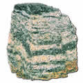 Baltimore gneiss:
1973 Geology Article Covers Baltimore Gneiss Geology
As GSA looks ahead to GSA 2015 in Baltimore, Maryland, USA, on 1–4 November, we reproduce here the first Geology * journal article published on the structural geology of Baltimore and its surrounds. The study by Michael W. Higgins, George W. Fisher, and Isidore Zietz also gives a sense of the geologic mapping there as it examines the extent of the Baltimore Gneiss.
Two of the authors cited in this paper have major GSA awards named for them. Florence Bascom, the first woman hired by the USGS (1896) and the first woman vice president of GSA (1930), was well known for her geologic mapping; thus, GSA’s newest award has been named for her: “Geologic Mapping Award in Honor of Florence Bascom.” Randolph W. “Bill” Bromery†, GSA’s first African-American president (1989), established the “Randolph W. ‘Bill’ and Cecile T. Bromery Award for Minorities” in 1999.
Would you like to know more about the early science and history of Baltimore? Have a look at this 1892 open-access (thanks to the Internet Archive Digital Library) Guide to Baltimore with an Account of the Geology of its Environs, by the American Institute of Mining Engineers.
*Geology, v. 1, p. 41–43, doi: 10.1130/0091-7613(1973)1<41:ADOABG>2.0.CO;2. All GSA journals and books are posted online at www.gsapubs.org.
†Bromery’s GSA Presidential Address is online at gsabulletin.gsapubs.org/content/102/3/405.full.pdf.
GEOLOGY Rerun: Aeromagnetic Discovery of a Baltimore Gneiss Dome in the Piedmont of Northwestern Delaware and Southeastern Pennsylvania
| Table of Contents |
|---|
|
Search GoogleScholar for
Search GSA Today |
ABSTRACT
In the central Appalachian Piedmont the “basement complex” is an assemblage of 1,100- to 1,300-m.y.-old gneisses, migmatites, and amphibolites that crops out in “domes” mantled by younger metasedimentary rocks of the Glenarm Series. Aeromagnetic data and reconnaissance fieldwork indicate that a previously unknown Baltimore Gneiss dome, here called the Mill Creek dome, is present in southeastern Pennsylvania and northwestern Delaware. The discovery of previously unknown domes of Baltimore Gneiss has bearing on the thickness, structure, and regional relations of the Glenarm Series.
Original Geology manuscript received 26 Feb. 1973; manuscript accepted 3 July 1973.
Introduction
The oldest rocks in the central Appalachian Piedmont are a complex of 1,100- to 1,300-m.y.-old (Tilton and others, 1958; Wetherill and others, 1966; Wetherill and others, 1968; Sinha and others, 1970) gneisses, migmatites, and amphibolites, collectively named the Baltimore Gneiss (Williams, 1892; Hopson, 1964). In Maryland, Baltimore Gneiss crops out in the cores of seven anticlinal domes (Fig. 1), true “mantled gneiss domes” (Eskola, 1949; Hopson, 1964) where the gneiss is unconformably overlain by metasedimentary rocks of the Glenarm Series (Knopf and Jonas, 1922, 1923; Hopson, 1964; Higgins, 1972). Baltimore Gneiss is also known to crop out in four anticlinal areas in southeastern Pennsylvania (Knopf and Jonas, 1923; Bascom and Stose, 1932; McKinstry, 1961; Gray and others, 1960; Fig. 1, this paper), where it is unconformably overlain by Glenarm Series rocks, or by Chilhowee Group rocks correlative with the Glenarm rocks (Higgins, 1972).
|
Generalized map of central Appalachian region, showing domes of “basement, complex” Baltimore Gneiss (line pattern) and approximate outline of newly discovered Mill Creek dome (dot pattern). (Editor’s note: Dot pattern did not show through on original.) |
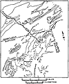 Figure 1
In most of the Baltimore Gneiss domes the gneiss is unconformably overlain by feldspathic mica schist, mica gneiss, feldspathic quartzite, and micaceous quartzite of the Setters Formation (Hopson, 1964). These quartzose rocks are overlain by marble, metadolomite, and calc-silicate rocks of the Cockeysville Marble (Choquette, 1960; Hopson, 1964), which, in turn, is overlain by a thick sequence of metasedimentary and metavolcanic rocks of the Wissahickon and James Run Formations (Knopf and Jonas, 1923; Hopson, 1964; Southwick and Fisher, 1967; Higgins and Fisher, 1971; Higgins, 1972). In some of the domes, however, the Setters rocks are absent, and the Cockeysville Marble, or even Wissahickon rocks, rests directly upon Baltimore Gneiss. In some cases this is due to faulting or to tectonic thinning (McKinstry, 1961; Hopson, 1964), but in others it is probably due to pre-Wissahickon erosion or to nondeposition of the lower Glenarm rocks (Choquette, 1960; Hopson, 1964). Fisher (1971) has shown that the Setters Formation is not everywhere a quartzose rock, however, and may be locally mistaken for Wissahickon pelitic schist.
The thickness of the Wissahickon Formation is not precisely determined because it is isoclinally folded and because there are few marker beds or units. The discovery of previously unknown domes of the “basement” Baltimore Gneiss in areas mapped as Wissahickon has bearing on the thickness of the Wissahickon as well as on the structure and regional relations of the Glenarm Series.
Mill Creek Dome
On aeromagnetic maps of the area around Baltimore (Bromery and others, 1964; Bromery, 1967; I. Zietz and J.R. Kirby, unpub. data), some of the northernmost Baltimore Gneiss domes coincide with distinctive deep magnetic lows. This is also true for some of the gneiss domes in southeastern Pennsylvania (I. Zietz and J.R. Kirby, unpub. data). In southeastern Pennsylvania and northwestern Delaware, near the common border of these states with Maryland, aeromagnetic maps (Henderson and others, 1963; Fig. 2, this paper) show a large magnetic low, similar in style and intensity to the lows associated with some of the gneiss domes near Baltimore. Some geologic maps of this area (Bascom and Miller, 1920; Bascom and Stose, 1932; Gray and others, 1960) show discontinuous outcrop areas of marble (Bascom and Stose and Gray and others called it Cockeysville Marble) coinciding with the gradient on the edges of the magnetic low. No Setters Formation rocks are shown in this area on any of the maps. On all the maps except Bascom and Miller’s (1920), the rocks that coincide with the main part of the magnetic low are shown as Wissahickon Formation with intercalated hornblende gneisses (amphibolites). Bascom and Miller (1920), on the other hand, mapped all the coarse-grained schists and gneisses in this region as Baltimore Gneiss, including large areas of rock now known to be Wissahickon and making no distinction between the older rocks and the overlying Glenarm Series.
|
Aeromagnetic map of part of southeastern Pennsylvania, northwestern Delaware, and northeastern Maryland. Deep magnetic low (patterned) approximately outlines Mill Creek dome of Baltimore Gneiss, Setters Formation, and Cockeysville Marble. |
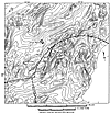 Figure 2
The distinctive magnetic expression, coupled with the known outcrops of marble and the recently emphasized fact that the Setters Formation is not everywhere a quartzite or quartz schist (Hopson, 1964; Fisher, 1971), led us to suspect that a dome of Baltimore Gneiss might be present in the area of the magnetic low. Reconnaissance field work has indicated that this is indeed the case.
The marble that crops out in the valley of Pike Creek near Pleasant Hill, Delaware, in the Mill Creek Valley near Hockessin, Delaware, and in the valley of Broad Run southeast of Landenberg, Pennsylvania (all these outcrop areas coincide generally with the gradient at the edges of the deep magnetic low; see Fig. 2), is lithologically identical to parts of the Cockeysville Marble (see Hopson, 1964, p. 69–70). Although outcrops of the marble are few, even in the areas listed above, topography and soils suggest that its distribution is more continuous than shown on existing geologic maps. Feldspathic and micaceous quartz schists that probably belong to the Setters Formation are intermittently exposed adjacent to the marble valleys. The rocks that coincide with the main part of the deep magnetic low (Fig. 2), and apparently lie stratigraphically beneath the quartz schists and marble, are a complex of biotite gneisses and migmatites, with numerous intercalations of coarse-grained amphibolites (Table 1); except for the greater abundance of amphibolites, these rocks are strikingly similar to the Baltimore Gneiss in the Maryland domes (see Hopson, 1964). They are lithologically distinct from the Wissahickon schists and gneisses that are exposed in the area—for example, in the valley of Pike Creek, on the other side of the marble outcrop belt.
|
Modal composition of gneisses from Mill Creek dome |
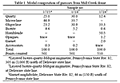 Table 1
Conclusions
Aeromagnetic data and reconnaissance field work indicate that a previously unknown dome of Baltimore Gneiss is present in southeastern Pennsylvania and northwestern Delaware. The gneiss in the dome appears to be surrounded by a discontinuous outcrop belt of feldspathic and micaceous Setters Formation quartz schists, and these schists, in turn, by a discontinuous outcrop belt of Cockeysville Marble. Wissahickon pelitic schists and gneisses flank the marble. We propose that this dome of Baltimore Gneiss be called the Mill Creek dome, for Mill Creek County, Delaware, which encompasses most of it.
Detailed geologic mapping is still needed to determine the exact distribution of the geologic units associated with the Mill Creek dome and to determine the detailed structure of the dome. The aeromagnetic maps (Henderson and others, 1963; I. Zietz and J.R. Kirby, unpub. data) should prove valuable aids to this mapping.
REFERENCES CITED
- Bascom, Florence, and Miller, B.L., 1920, Description of the Elkton-Wilmington quadrangles [Maryland-Delaware-New Jersey-Pennsylvania]: U.S. Geol. Survey Geol. Atlas, Folio 211, 22 p.
- Bascom, Florence, and Stose, G.W., 1932, Description of the Coatesville-West Chester quadrangles [Pennsylvania]: U.S. Geol. Survey Geol. Atlas, Folio 223, 15 p.
- Bromery, R.W., 1967, Aeromagnetic map of Baltimore County and Baltimore City, Maryland: U.S. Geol. Survey Geophys. Inv. Map GP-613.
- Bromery, R.W., Petty, A.J., and Smith, C.W., 1964, Aeromagnetic map of Bel Air and vicinity, Harford, Baltimore, and Cecil Counties, Maryland: U.S. Geol. Survey Geophys. Inv. Map GP-482.
- Choquette, P.W., 1960, Petrology and structure of the Cockeysville Formation (pre-Silurian) near Baltimore, Maryland: Geol. Soc. America Bull., v. 71, no. 7, p. 1027–1052.
- Eskola, Pentti, 1949, The problem of mantled gneiss domes: Geol. Soc. London Quart. Jour., v. 104, pt. 4, no. 416, p. 461–476.
- Fisher, G.W., 1971, Kyanite-, staurolite-, and garnet-bearing schists in the Setters Formation, Maryland Piedmont: Geol. Soc. America Bull., v. 82, no. 1, p. 229–232.
- Gray, Carlyle, and others, compilers, 1960, Geologic map of Pennsylvania: Harrisburg, Pennsylvania Geol. Survey, 4th ser., scale 1:250,000.
- Henderson, J.R., Johnson, R.W., and Gilbert, F.P., 1963, Aeromagnetic map of the Wilmington, Delaware, area and adjacent parts of Pennsylvania and Maryland: U.S. Geol. Survey Geophys. Inv. Map GP-363.
- Higgins, M.W., 1972, Age, origin, regional relations, and nomenclature of the Glenarm Series, central Appalachian Piedmont: A reinterpretation: Geol. Soc. America Bull., v. 83, no. 4, p. 989–1026.
- Higgins, M.W., and Fisher, G.W., 1971, A further revision of the stratigraphic nomenclature of the Wissahickon Formation in Maryland: Geol. Soc. America Bull., v. 82, no. 3, p. 769–774.
- Hopson, C.A., 1964, The crystalline rocks of Howard and Montgomery Counties, in The geology of Howard and Montgomery Counties: Baltimore, Maryland Geol. Survey, p. 27–215.
- Knopf, E.B., and Jonas, A.I., 1922, Stratigraphy of the crystalline schists of Pennsylvania and Maryland [abs.]: Geol. Soc. America Bull., v. 33, no. l, p. 110–111.
- Knopf, E.B., and Jonas, A.I., 1923, Stratigraphy of the crystalline schists of Pennsylvania and Maryland: Am. Jour. Sci., v. 5, p. 40–62.
- McKinstry, Hugh, 1961, Structure of the Glenarm Series in Chester County, Pennsylvania: Geol. Soc. America Bull., v. 72, no. 4, p. 557–578.
- Sinha, A.K., Higgins, M.W., Davis, G.L., Hart, S.R., and Kirk, W.S., 1970, The Glenarm Series and related rocks: Carnegie Inst. Washington Year Book 69, p. 412–413.
- Southwick, D.L., and Fisher, G.W., 1967, Revision of stratigraphic nomenclature of the Glenarm Series in Maryland: Maryland Geol. Survey Rept. Inv. 6, 19 p.
- Tilton, G.R., Wetherill, G.W., Davis, G.L., and Hopson, C.A., 1958, Ages of minerals from the Baltimore Gneiss near Baltimore, Maryland: Geol. Soc. America Bull., v. 69, no. 11, p. 1469–1474.
- Wetherill, G.W., Tilton, G.R., Davis, G.L., Hart, S.R., and Hopson, C.A., 1966, Age measurements in the Maryland Piedmont: Jour. Geophys. Research, v. 71, no. 8, p. 2139–2155.
- Wetherill, G.W., Davis, G.L., and Lee-Hu, C., 1968, Rb-Sr measurements on whole rocks and separated minerals from the Baltimore Gneiss, Maryland: Geol. Soc. America Bull., v. 79, no. 6, p. 757–762.
- Williams, G.H., 1892, Guide to Baltimore, with an account of the geology of its environs (Am. Inst. Mining Engineers, Baltimore mtg., 1892): Baltimore, J. Murphy and Co., 139 p.
Acknowledgments
L.C. Pakiser reviewed the manuscript. J.R. Kirby assisted in valuable discussions related to the aeromagnetic map. Publication authorized by the Director, U.S. Geological Survey.