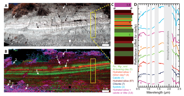
Figure 5.
(A) Color composite image approximating true color of an outcrop along Mills Creek imaged with UCIS. (B) Spectral parameter map. Red is the band depth of a spectral feature at 2.21 µm (BD2210) due to Si-OH and/or Al-OH combination absorptions. Green is the band depth of a feature at 2.31–2.32 µm (BD2310-20) likely due to Mg-OH combinations. Blue is the band depth of a feature at 2.34–2.35 µm (BD2340-50) due to either a C-O combination in calcite or Fe-OH combinations in a mineral such as chlorite or epidote (Clark et al., 1990). (C) Schematic lithostratigraphic section from area outlined in yellow boxes in (A) and (B) with colors corresponding to the colors in (B). Dark green layers have weak Fe/Mg/Al clay features. Other colors correspond with minerals names under the stratigraphic section. (D) Example spectra of different units with colors corresponding to (B) and (C). Locations of each spectrum are numbered on both images. Dashed lines are, from left to right, at 2.21, 2.31, and 2.34 µm, corresponding with the positions of spectral features mapped in (B). Spectral regions with terrestrial atmosphere are removed and covered with light gray boxes.