
Full Text View
Volume 24 Issue 2 (February 2014)
GSA Today
![]()
Article, pp. 4-10 | Abstract | PDF (3.8 MB)
Boulders of the Vastitas Borealis Formation: Potential origin and implications for an ancient martian ocean
| Table of Contents |
|---|
|
Search GoogleScholar for
Search GSA Today |
ABSTRACT
The hypothetical existence of a martian ocean that is based on identification of alleged paleoshorelines has been heavily contested during recent years. Despite the controversy surrounding the paleoshoreline interpretation, additional evidence supporting the idea of a late Hesperian–early Amazonian martian ocean has recently been documented in areas that were potentially covered by this body of water. Most of these observations have been made by the establishment of analogies between martian features within the northern plains and depositional elements from deep-water terrestrial environments (e.g., teardrop-shaped islands, large-scale polygonal terrains, and high-albedo mounds). This paper showcases a new terrestrial, deep-water analogy that also supports the existence of an ancient martian ocean. Boulder-size rocks that are contained within the Vastitas Borealis Formation (VBF) on the northern plains of Mars are compared with boulder- and kilometer-scale blocks that have been transported subaqueously as part of mass-transport events in a multitude of terrestrial deep-water environments. These observations suggest that meter-scale rocks that make up part of the VBF might have been emplaced by catastrophic mass-transport events similar to those documented within continental margins on Earth.
*Email:
Manuscript received 20 Aug. 2013; accepted 5 Sept. 2013
DOI: 10.1130/GSATG197A.1
Introduction
The existence of an ancient martian ocean on the northern plains of Mars was originally postulated on the basis of the identification of paleoshorelines using Viking Orbiter images (Parker et al., 1989, 1993); however, this line of evidence has been heavily questioned because these contacts have significant variations in elevation, and some of them have turned out to be of volcanic origin (Carr and Head, 2003). The Vastitas Borealis Formation (VBF) is an upper Hesperian to lower Amazonian unit that was deposited in the northern martian lowlands and that is contemporaneous with the genesis of outflow channels (Tanaka and Scott, 1987; Kreslavsky and Head, 2002). The hypothetical existence of an ocean occupying the northern plains of Mars during late Hesperian–early Amazonian time (Baker et al., 1991) would imply that the VBF was deposited under marine conditions (Carr and Head, 2003). The VBF occupies 45% of the northern lowlands, containing knobby, mottled, and grooved terrains that have been linked by some researchers to marine processes (Kreslavsky and Head, 2002). Despite the marine hypothesis, different origins have been postulated to explain the occurrence of the VBF, and this topic remains under the scrutiny of the planetary science community (Carr and Head, 2003; McEwen et al., 2007). The paleoshoreline controversy (Parker et al., 1989, 1993) has driven the search for evidence of an ancient martian ocean to deposits located on the northern plains rather than at the outer margins of this hypothetical body of water (Carr and Head, 2003). In recent years, significant progress has been made in documenting terrestrial analogues for the deposits located on the northern plains of Mars that are consistent with the existence of a late Hesperian–early Amazonian martian ocean. These terrestrial analogues include (1) a resemblance between teardrop-shaped islands located on the downstream end of outflow channels on Mars and erosional shadow remnants documented in deep-water terrestrial environments (Moscardelli and Wood, 2011); (2) similarities between large-scale polygonal terrains on Mars and deep-water polygonal fault systems on Earth (Cooke et al., 2011; Allen et al., 2013; Moscardelli et al., 2012); and (3) comparisons between high-albedo mounds in Acidalia Planitia and terrestrial submarine mud volcanoes (Allen et al., 2013; Oehler and Allen, 2012) (Fig. 1). This work seeks to showcase an additional terrestrial, deep-water analogy that also supports the hypothetical existence of a late Hesperian to early Amazonian martian ocean. Boulder-size rocks contained within the VBF (Fig. 2) are compared with blocks and boulders that have been seismically imaged in deep-water terrestrial environments (Fig. 3) (Lee et al., 2004; Alves, 2010; Dunlap et al., 2010; Jackson, 2011, 2012) and reported in outcrop locations (Macdonald et al., 1993; Slatt et al., 2000; Dykstra et al., 2011) (Fig. 4). This new analogy is also placed into a broader context that supports a subaqueous origin for the VBF.
|
(A) Teardrop-shaped islands (TSIs) on downstream end of Ares Vallis (THEMIS V01786010). (B) Erosional shadow remnants (ESRs) in a deep-water Pliocene–Pleistocene stratigraphic succession of eastern offshore Trinidad (root-mean-square [RMS] attribute extraction map). (C) Large-scale polygonal terrains in Acidalia Planitia (HiRISE PSP_006636_2260). (D) Deep-water polygonal fault system in offshore Norway, Brygge Formation (RMS attribute extraction map). (E) High-albedo mounds in Acidalia Planitia (HiRISE PSP_008522_2210). (F) Mud volcanoes on the slope region of eastern offshore Trinidad (RMS attribute extraction map). |
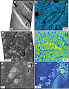 Figure 1
|
Knobby terrains in Arcadia Planitia (HiRISE ESP_019853_2410). |
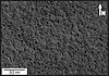 Figure 2
|
Cross section highlighting character of megablocks and other submarine mass-transport deposit (MTD) seismic facies in the Santos Basin (offshore Brazil). Image facilitated by Christopher Jackson and courtesy of CGGVeritas. TWT—two-way travel time. |
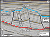 Figure 3
|
Megablocks of varying sizes embedded within mass-transport deposits of the Jackfork Group in Arkansas, USA. (A) DeGray Lake Spillway location. (B) Pinnacle State Park exposure. Image facilitated by Roger Slatt. |
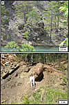 Figure 4
Terrestrial Mass-Transport Deposits
Submarine mass-transport deposits (MTDs) are generated by the action of gravity-driven processes affecting sediments within continental margins. Mass-transport events are linked to laminar flows, but not to Newtonian flows, which are commonly associated with the formation of turbidites (Dott, 1963; Nardin et al., 1979; Moscardelli and Wood, 2008). Slides, slumps, and debris flows are constituents of MTDs and can co-occur in the same event or depositional unit (Moscardelli and Wood, 2008). Mass-transport events have a high recurrence rate on continental margins and can remobilize huge volumes of sediments; as a consequence, associated MTDs often form a significant component of the stratigraphic column in both ancient and modern deep-water successions (Moscardelli and Wood, 2008). Grains within mass-wasting events are transported and sustained by a muddy matrix in a laminar flow, and finding boulder- to kilometer-size blocks contained within MTDs is not uncommon (Macdonald et al., 1993; Lee et al., 2004; Alves, 2010; Dunlap et al., 2010; Dykstra et al., 2011; Jackson, 2011, 2012). A good example of boulder-size rocks embedded within the muddy matrix of a MTD can be observed in the outcrops of the Carboniferous Guandacol Formation in the Pangazo Basin, Argentina (Dykstra et al., 2011). The Guandacol MTD, 120 m thick, contains granule- to boulder-size clasts of granitoid and metamorphic basement rocks, as well as allochthonous blocks of sandstones. The sizes of the sandstone blocks can vary from a few meters to tens of meters in width and a few meters to ~10 m in thickness. These boulders and blocks are interpreted as having been removed from underlying units and incorporated into the mass-transport flow during emplacement of the Guandacol MTD (Dykstra et al., 2011). Spectacular MTD blocks also crop out as part of the Ablation Point Formation on Alexander Island. This unit forms part of the Jurassic–Cretaceous Fossil Bluff Group in the Antarctic Peninsula (Macdonald et al., 1993). The Ablation Point MTD, which can reach a total thickness of 400 m, contains abundant resedimented blocks of older volcanic rocks and turbidite sandstones. More accessible outcrops containing megablocks with variable sizes are located in the Pennsylvanian Jackfork Group of south-central Arkansas, where blocks of resedimented sandstone turbidites crop out in a variety of locations (Slatt et al., 2000) (Fig. 4). Individual blocks can reach >25 m in thickness and >100 m in length. Identification of MTD blocks in outcrops can be challenging because the scale of exposure might not be adequate for recognition of the presence of allochthonous blocks that can be hundreds of meters thick and kilometers long (Macdonald et al., 1993) (Fig. 5).
|
Relationship between length and thickness of reported deep-water megablocks from both outcrop and subsurface locations. A—Member A1, Ablation Point Fm. (Antarctica); B—Member A2, Ablation Point Fm. (Antarctica); C—Member B6, Ablation Point Fm. (Antarctica); D—Himalia Ridge (Antarctica); E—Tertiary Tejas A Fm., Tarfaya-Agadir Basin (Morocco); F—Cretaceous MTD, Safi Haute Mer (Morocco); G—Cretaceous MTD, Santos Basin (Brazil); H—Tertiary attached MTD, Santos Basin (Brazil); I—Miocene MTD, Espiritu Santo Basin (Brazil). Data collected from Macdonald (1993), Lee et al. (2004), Alves (2010), Dunlap et al. (2010), and Jackson (2011, 2012). MTD—detached submarine mass-transport deposit. |
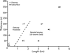 Figure 5
More recently, acquisition of high-resolution remote-sensing information in the marine realm has allowed for a better appreciation of architectural elements associated with a variety of deep-water deposits, including MTDs. In this context, the three-dimensionality of MTD blocks has been described exhaustively in the subsurface, and now we have a better idea of the processes associated with their emplacement (Lee et al., 2004; Moscardelli et al., 2006; Alves, 2010; Dunlap et al., 2010; Jackson, 2011, 2012). Jackson (2011) documented the architecture of large MTD blocks that he called megaclasts in the Santos Basin, where the host MTDs were generated by slope failures off the Brazilian continental margin during the Tertiary (Modica and Brush, 2004). The Santos Basin Tertiary megaclasts are located in the distal part of a regional MTD that is 350 m thick and that covers a minimum area of 5000 km2 (Jackson, 2011; see his figure 2). Individual Tertiary megaclasts can be 5 km long and 350 m thick and can cover 10 km2 areas (Fig. 3). Sediment volume of individual megaclasts has been estimated at ~7 km3 (Fig. 5). Tertiary megaclasts in the Santos Basin also feature a high degree of internal deformation that is manifested by the presence of abundant faults and folds that were generated during emplacement (Jackson, 2011) (Fig. 3). Smaller megablocks associated with the collapsing flanks of salt diapirs during the Cretaceous have also been documented within detached MTDs covering ~50 km2 in the Santos Basin (Jackson, 2012; see his figures 4 and 6). These Cretaceous megaclasts can reach 50 m in thickness, 1.5 km in length, and can cover 1 km2 areas (Fig. 5) (Jackson, 2012). The vertical and horizontal resolution of the 3-D seismic volume that was used to describe both Tertiary and Cretaceous megaclasts in the Santos Basin is 10 m and 12.5 m, respectively (Jackson, 2011, 2012). In other words, any internal elements, such as boulders or smaller blocks, <10 m thick and <12.5 m in plan view would be difficult to image using this seismic volume. However, note that these Tertiary and Cretaceous megaclasts most likely underwent some degree of disaggregation during transport, similar to that observed for MTD blocks in the Guandacol Formation in Argentina, where smaller boulders are the byproducts of megaclast disaggregation (Dykstra et al., 2011). Identification of MTD blocks or megaclasts in the subsurface is not exclusive to the Santos Basin, and many authors have documented their presence in other settings (Fig. 5). Alves (2010) documented the presence of similar Miocene megaclasts in the Espiritu Santo Basin in offshore Brazil (see his figures 1 and 2). Lee et al. (2004) (see their figure 4) and Dunlap et al. (2010) (see their figure 21) reported the presence of Cretaceous-age blocks that can reach 4 km2 in area and 200 m in thickness in offshore Morocco. Moscardelli et al. (2006) showcased scour marks in the deep-water region of eastern offshore Trinidad that had been generated by the transport of big blocks during a debris-flow event. The evidence suggests that a wide range of boulder- to megaclast-size blocks is ubiquitous in terrestrial submarine MTDs.
Analogy between VBF Blocks and MTD Megaclasts and Boulders
The origin of the VBF remains debatable, with some hypotheses suggesting that the genesis of this unit is linked to processes that took place in an ancient ocean in which most of the sediments had been transported and deposited as a suspended-sediment load (Kreslavsky and Head, 2002). Other researchers have suggested that the VBF is the result of frozen deposits of sediment-laden water that originated from giant outflow channels (Carr and Head, 2003). HiRISE (high-resolution imaging science experiment) images over the northern plains of Mars have revealed the presence of boulders that form part of the VBF and that can range in size from 0.5 to 2 m in diameter (Fig. 2). McEwen et al. (2007) pointed out that the boulder distribution within the VBF is difficult to reconcile with the hypothesis that the unit consists primarily of a thick deposit of fine-grained materials that settled out of sediments suspended in an ancient martian ocean. However, recent advances in 3-D seismic-reflectivity–imaging techniques, drawn mainly from offshore oil and gas exploration activities around the world, have allowed us to uncover geomorphological complexities within deep-water environments that have changed our perception of how depositional processes operate in the marine realm. We have come to see that sedimentation processes in oceans are not exclusively dominated by suspended sediment load and that the spectrum of high-energy, dynamic processes operating in these deep-water environments is wide. Mass-transport events are one of the many processes that can generate deep-water deposits that can cover hundreds to thousands of square kilometers (Lee et al., 2004; Alves, 2010; Dunlap et al., 2010; Jackson, 2011, 2012; among many others). Terrestrial analogs clearly demonstrate that subaqueous MTDs can mobilize huge amounts of sediment into deep-water basins. One of the largest documented terrestrial MTDs on record, the Pleistocene Børnøja Fan Slide Complex, was described in the Barents Sea at water depths of 3,000 m (Hjelstuen et al., 2007). The Børnøja Fan Slide Complex remobilized 25,000 km3 of glaciogenic sediments and covered a 120,000-km2 area during the Northern Hemisphere Glaciation (Hjelstuen et al., 2007). Given these terrestrial analogies, it would be plausible that boulders contained within the VBF were transported to the northern plains of Mars as the result of catastrophic mass-wasting events associated with the debouchment of sediments from outflow channels during late Hesperian–early Amazonian time. The presence of boulders within the VBF does not present a conflict with a potential subaqueous origin for this unit, in which the water-sediment interface could have enhanced the capacity of the flow to erode and transport boulder-size rocks.
Alternative hypotheses have been offered to explain the emplacement mechanisms of blocks observed within the VBF. One of these suggests that VBF boulders were ejected as the product of meteorite impacts (Catling et al., 2011, 2012). Undoubtedly, meteorite impacts have the capacity to disrupt the targeted substratum, and some of the boulders observed on the northern plains of Mars could have been emplaced as the result of these processes. However, HiRISE imagery clearly shows impact-free boulder fields within the VBF that occupy hundreds of square kilometers (Fig. 2). This implies that a causal link between meteorite impacts and boulder occurrence is very unlikely. While the meteorite impact hypothesis can certainly explain the occurrence of some of the boulders observed on the northern plains of Mars, especially those that occur in close proximity to impact craters, it does not provide a comprehensive mechanism to understand the wide distribution of boulders in these regions. It has also been argued that periglacial activity associated with recent ice deposition might be involved in the formation of patterned grounds containing boulders in the northern plains of Mars (Milliken et al., 2003; Head et al., 2003; Levy et al., 2010). However, the VBF is an older unit of late Hesperian–early Amazonian age, and a variety of geomorphological patterns contained within this unit can be better explained by establishing a marine origin (Cooke et al., 2011; Moscardelli and Wood, 2011; Moscardelli et al., 2012; Oehler and Allen, 2012; Allen et al., 2013). The link between boulders in the northern plains of Mars and submarine processes is supported not only by a direct analogy with what could represent their terrestrial counterparts (megablocks) but also by placing their occurrence into a broader context that is conducive to supporting a marine origin (Parker et al., 1989, 1993; Cooke et al., 2011; Moscardelli and Wood, 2011; Moscardelli et al., 2012; Allen et al., 2013).
Discussion
Discussion of the hypothetical existence of a late Hesperian–early Amazonian ocean on Mars should not revolve exclusively around an acceptance or rejection of a single line of evidence (e.g., the paleoshoreline argument). Search for additional evidence to support the idea of a hypothetically ancient ocean on the northern plains of Mars should also expand to areas presumably covered by water (Carr and Head, 2003). In this context, documentation of kilometer-scale blocks and boulders in a variety of terrestrial, deep-water deposits suggests that the occurrence of boulder-size rocks in the VBF does not preclude a subaqueous origin for this unit. Therefore, portions of the VBF may very well have been deposited as part of underwater MTDs. The meter-scale boulders that have been revealed by HiRISE images could have been transported by mass-wasting events associated with the formation of outflow channels and deposited in Oceanus Borealis (Baker et al., 1991). The presence of boulders within the VBF is not the only analogy within the rim of the martian northern plains that supports the existence of an ancient ocean. A multitude of recently documented terrestrial analogs also support this marine hypothesis (Allen et al., 2013; Cooke et al., 2011; Moscardelli and Wood, 2011; Moscardelli et al., 2012; Oehler and Allen, 2012) (Fig. 1). Major arguments against the paleoshoreline interpretation of Parker et al. (1989, 1993) highlight the significant variations in elevation associated with these boundaries. These arguments are valid in a scenario in which the absence of tectonism and associated structural deformation could not justify postdepositional deformation of the alleged paleoshorelines. However, the recent discovery of potentially large-scale and narrow strike-slip faults in the Valles Marineris region has raised questions about the tectonic quiescence of Mars (Yin, 2012). These findings suggest that the Tharsis Rise experienced two major episodes of tectonism during late Hesperian and late Amazonian times (Yin, 2012). If there had been active tectonism on Mars, then these processes could have deformed the paleoshorelines and caused the observed changes in elevation, circumventing earlier arguments against previous interpretations (Parker et al., 1989, 1993). In addition, alteration of the alleged paleoshorelines by the action of true polar wander has also been suggested as an alternative mechanism of deformation (Perron et al., 2007).
Evidence supporting the existence of Oceanus Borealis (Baker et al., 1991) goes beyond the identification of terrestrial, deep-water geomorphological analogies. Data from the Mars Advanced Radar for Subsurface and Ionospheric Sounding (MARSIS) also support a subaqueous origin of the VBF by reporting a low, dielectric constant associated with these deposits (Mouginot et al., 2012). However, data from the shallow subsurface radar (SHARAD) suggest that the VBF presents far greater heterogeneities than those reported by MARSIS. These heterogeneities are expressed by the presence of terrains that have a closer affinity with low-loss basaltic flows or ashes in areas such as Amazonis Planitia (Boisson et al., 2011). The potential presence of basaltic-like terrains on the northern plains of Mars is considered by some as an impediment to support a late Hesperian–early Amazonian oceanic hypothesis (Catling et al., 2012); however, it has also been suggested that these terrains are in fact weathered basalts that degraded under marine conditions (Wyatt and McSween, 2002). These apparent contradicting views reflect the complexities associated with the acquisition, processing, and proper interpretation of radar data on Mars. The ground-penetrating radar (GPR) that will be launched in 2018 as part of the European Space Agency’s ExoMars rover will include an instrument capable of operating over a much broader and higher-frequency range that will hopefully provide additional data to complement the observations already made by MARSIS and SHARAD.
Baker et al. (2000) also hypothesized that the Olympus Mons aureole deposits are subaqueous MTDs similar to those described in the Hawaiian Islands (Moore et al., 1989). This interpretation would imply that the total volume of water occupying the northern plains of Mars would have been equivalent to 3.5 × 10⁸ km3 (Carr and Head, 2003). Under this scenario, the paleoshorelines of Parker et al. (1989, 1993) were most likely submerged, raising the question of the validity of a coastline interpretation for these lineations. Carr and Head (2003) also pointed out the difficulty in identifying features that could exclusively indicate paleoshorelines in the northern plains, because these zones overlap with layering in bedrock and mass wasting. If the paleoshorelines of Parker et al. (1989, 1993) had been submerged, then the break in slope (martian dichotomy) could be better explained by the presence of a paleoshelf-break where mass-wasting processes would have been prevalent. The suggestion that teardrop-shaped islands might have formed in a continental-slope setting (Moscardelli and Wood, 2011) supports the paleoshelf-break hypothesis to explain the martian dichotomy, indicating that we might need to raise estimates of the volume of water that once occupied the northern plains of Mars (Newton, 2011). The potential existence of a martian ocean will be a topic of debate for many years to come. In an increasingly data-rich environment, where remote information from a multitude of martian missions and instruments is constantly pouring into the planetary geology community, we need to ensure that proper data integration with a wide range of disciplines is achieved. Knowledge derived from seismic geomorphological analysis of deep-water systems on Earth has proven to be useful for the establishment of new terrestrial analogies that support the existence of a martian ocean. Verification of this hypothesis will only arrive with direct access to uncontaminated samples.
Acknowledgments
This research was made possible through the generous support of members of the Quantitative Clastics Laboratory (QCL) at the Bureau of Economic Geology and by a grant from the Jackson School of Geosciences of The University of Texas at Austin. Seismic data are courtesy of CGGVeritas, Statoil, ConocoPhillips, and the Norwegian Petroleum Directorate. The University of Texas at Austin acknowledges support of this research by Landmark Graphics Corporation via the Landmark University Grant Program. We thank the editor of GSA Today, Bernard Housen, and two anonymous reviewers for useful comments on an earlier version of this manuscript. Special thanks to Dr. Christopher Jackson from Imperial College of London for helping to secure access to seismic data from the Santos Basin and to Dr. Roger Slatt from the University of Oklahoma for facilitating access to outcrops of the Jackfork Group in Arkansas. Dr. Tim Dooley is thanked for providing insightful comments about this work. Publication of this paper is authorized by the Director, Bureau of Economic Geology, Jackson School of Geosciences, The University of Texas at Austin.
References Cited
- Allen, C.C., Oehler, D.Z., Etiope, G., Van Rensbergen, P., Baciu, C., Feyzullayev, A., Martinelli, G., Tanaka, K., and Van Rooij, D., 2013, Fluid expulsion in terrestrial sedimentary basins: A process providing potential analogs for giant polygons and mounds in the martian lowlands: Icarus, v. 224, p. 424–432, doi: 10.1016/j.icarus.2012.09.018.
- Alves, T.M., 2010, 3D seismic examples of differential compaction in mass-transport deposits and their effect on post-failure strata: Marine Geology, v. 271, no. 3–4, p. 212–224, doi: 10.1016/j.margeo.2010.02.014.
- Baker, V.R., Strom, R.G., Gulick, V.C., Kargel, J.S., Komatsu, G., and Kale, V.S., 1991, Ancient oceans, ice sheets and the hydrological cycle on Mars: Nature, v. 352, p. 589–594, doi: 10.1038/352589a0.
- Baker, V.R., Dohm, J.M., Gulick, V.C., Kargel, J.S., Komatsu, G., and Rice, J.W., 2000, Mars: Oceanus Borealis, ancient glaciers and the MEGAOUTFLO hypothesis: 31st Annual Lunar and Planetary Science Conference, 13–17 March 2000, Houston, Texas, abstract no. 1863.
- Boisson, J., Heggy, E., Clifford, S.M., Yoshikawa, K., Anglade, A., and Lognonné, P., 2011, Radar sounding of temperate permafrost in Alaska: Analogy to the Martian midlatitude to high-latitude ice-rich terrains: Journal of Geophysical Research, v. 116, E11003, doi: 10.1029/2010JE003768.
- Carr, M.H., and Head, J.W., 2003, Oceans on Mars: An assessment of the observational evidence and possible fate: Journal of Geophysical Research, v. 108, E5, 5042, doi: 10.1029/2002JE001963.
- Catling, C., Leovy, C.B., Wood, S.E., and Day, M.D., 2012, Does the Vastitas Borealis Formation contain oceanic or volcanic deposits?: Third Conference on Early Mars: Geologic, Hydrologic, and Climatic Evolution and the Implications for Life, 21–25 May 2012, Lake Tahoe, Nevada: LPI Contribution no. 1680, abstract 7031.
- Catling, D.C., Leovy, C.B., Wood, S.E., and Day, M.D., 2011, A lava sea in the northern plains of Mars: Circumpolar Hesperian oceans reconsidered: 42nd Lunar and Planetary Science Conference, 7–11 March 2011, The Woodlands, Texas: LPI Contribution no. 1608, abstract 2529.
- Cooke, M., Islam, F., and McGill, G., 2011, Basement controls on the scale of giant polygons in Utopia Planitia, Mars: Journal of Geophysical Research–Planets, v. 116, E09003, doi: 10.1029/2011JE003812.
- Dott, R.H., 1963, Dynamics of subaqueous gravity depositional processes: AAPG Bulletin, v. 47, p. 104–128.
- Dunlap, D.B., Wood, L.J., Weisenberger, C., and Jabour, H., 2010, Seismic geomorphology of offshore Morocco’s east margin, Safi Haute Mer area: AAPG Bulletin, v. 94, no. 5, p. 615–642, doi: 10.1306/10270909055.
- Dykstra, M., Garyfalou, K., Kertznus, V., Kneller, B., Milana, J.P., Molinaro, M., Szuman, M., and Thompson, P., 2011, Mass-transport deposits: Combining outcrop studies and seismic forward modeling to understand lithofacies distributions, deformation, and their seismic stratigraphic expression, in Shipp, R.C., Weimer, P., and Posamentier, H.W., eds., Mass Transport Deposits in Deepwater Settings: SEPM Special Publication 96, p. 293–310.
- Head, J.W., Mustard, J.F., Kreslavsky, M.A., Milliken, R.E., and Marchant, D.R., 2003, Recent ice ages on Mars: Nature, v. 426, p. 797–802, doi: 10.1038/nature02114.
- Hjelstuen, B.O., Eldholm, O., and Faleide, J.I., 2007, Recurrent Pleistocene mega-failures on the SW Barents Sea margin: Earth and Planetary Science Letters, v. 258, p. 605–618, doi: 10.1016/j.epsl.2007.04.025.
- Jackson, C.A.-L., 2011, Three-dimensional seismic analysis of megaclast deformation within a mass transport deposit; implications for debris flow kinematics: Geology, v. 39, no. 3, p. 203–206, doi: 10.1130/G31767.1.
- Jackson, C.A.-L., 2012, The initiation of submarine slope failure and the emplacement of mass transport complexes in salt-related minibasins: A three-dimensional seismic-reflection case study from the Santos Basin, offshore Brazil: GSA Bulletin, v. 124, p. 746–761, doi: 10.1130/B30554.1.
- Kreslavsky, M.A., and Head, J.W., 2002, Fate of outflow channel effluents in the northern lowlands of Mars: The Vastitas Borealis Formation as a sublimation residue from frozen ponded bodies of water: Journal of Geophysical Research, v. 107, E12, 5121, doi: 10.1029/2001JE001831.
- Lee, C., Nott, J.A., and Keller, F.B., 2004, Seismic expression of the Cenozoic mass transport complexes, deepwater Tarfaya–Agadir Basin, Offshore Morocco: Offshore Technology Conference, 3 May–6 May 2004, Houston, Texas, 16741-MS, 18 p., doi: 10.4043/16741-MS.
- Levy, J.S., Marchant, D.R., and Head, J.W., 2010, Thermal contraction crack polygons on Mars: A synthesis from HiRISE, Phoenix, and terrestrial analog studies: Icarus, v. 206, p. 229–252, doi: 10.1016/j.icarus.2009.09.005.
- Macdonald, D., Moncrieff, A., and Butterworth, P., 1993, Giant slide deposits from a Mesozoic fore-arc basin, Alexander Island, Antarctica: Geology, v. 21, p. 1047–1050, doi: 10.1130/0091-7613(1993)021<1047:GSDFAM>2.3.CO;2.
- McEwen, A.S., and 32 others, 2007, A closer look at water-related geologic activity on Mars: Science, v. 317, 5845, p. 1706–1709, doi: 10.1126/science.1143987.
- Milliken, R.E., Mustard, J.F., and Goldsby, D.L., 2003, Viscous flow features on the surface of Mars: Observations from high-resolution Mars Orbiter Camara (MOC) images: Journal of Geophysical Research, v. 108, E6, 5057, doi: 10.1029/2002JE002005.
- Modica, C.J., and Brush, E.R., 2004, Postrift sequence stratigraphy, paleogeography, and fill history of the deep-water Santos Basin, offshore southeast Brazil: AAPG Bulletin, v. 88, p. 923–945, doi: 10.1306/01220403043.
- Moore, J.G., Clague, D.A., Holcomb, R.T., Lipman, P.W., Normark, W.R., and Torresan, M.E., 1989, Prodigious submarine landslides on the Hawaiian ridge: Journal of Geophysical Research, v. 94, B12, p. 17,465–17,484, doi: 10.1029/JB094iB12p17465.
- Moscardelli, L., and Wood, L., 2008, New classification system for mass transport complexes in offshore Trinidad: Basin Research, v. 20, p. 73–98, doi: 10.1111/j.1365-2117.2007.00340.x.
- Moscardelli, L., and Wood, L., 2011, Deep-water erosional remnants in eastern offshore Trinidad as terrestrial analogs for teardrop-shaped islands on Mars: Implications for outflow channel formation: Geology, v. 39, no. 7, p. 699–702, doi: 10.1130/G31949.1.
- Moscardelli, L., Wood, L., and Mann, P., 2006, Mass-transport complexes and associated processes in the offshore area of Trinidad and Venezuela: AAPG Bulletin, v. 90, p. 1059–1088, doi: 10.1306/02210605052.
- Moscardelli, L., Dooley, T., Dunlap, D., Jackson, M., and Wood, L., 2012, Deep-water polygonal fault systems as terrestrial analogs for large-scale Martian polygonal terrains: GSA Today, v. 22, no. 8, p. 4–9, doi: 10.1130/GSATG147A.1.
- Mouginot, J., Pommerol, A., Beck, P., Kofman, W., and Clifford, S.M., 2012, Dielectric map of the Martian northern hemisphere and the nature of plain filling materials: Geophysical Research Letters, v. 39, L02202, doi: 10.1029/2011GL050286.
- Nardin, T.R., Hein, F.J., Gorsline, D.S., and Edwards, B.D., 1979, A review of mass movement processes, sediment, and acoustic characteristics and contrasts in slope and base-of-slope systems versus canyon-fan-basin floor systems, in Doyle, L.J., and Pilkey, O.H., eds., Geology of Continental Slopes: SEPM Special Publication 27, p. 61–73, doi: 10.2110/pec.79.27.0061.
- Newton, A., 2011, Planetary science: From shore to shelf: Nature Geoscience, v. 4, p. 425, doi: 10.1038/ngeo1202.
- Oehler, D.Z., and Allen, C.C., 2012, Focusing the search for biosignatures on Mars: Facies prediction with an example from Acidalia Planitia, in Grotzinger, J., and Milliken, R., eds., Sedimentary Geology of Mars: SEPM Special Publication 102, p. 183–194.
- Parker, T.J., Saunders, R.S., and Schneeberger, D.M., 1989, Transitional morphology in west Deuteronilus Mesae, Mars—Implications for modification of the lowland upland boundary: Icarus, v. 82, no. 1, p. 111–145, doi: 10.1016/0019-1035(89)90027-4.
- Parker, T.J., Gorsline, D.S., Saunders, R.S., Pieri, D.C., and Schneeberger, D.M., 1993, Coastal geomorphology of the Martian northern plains: Journal of Geophysical Research–Planets, v. 98, E6, p. 11,061–11,078, doi: 10.1029/93JE00618.
- Perron, J.T., Mitrovica, J.X., Manga, M., Matsuyama, I., and Richards, M.A., 2007, Evidence for an ancient martian ocean in the topography of deformed shorelines: Nature, v. 447, p. 840–843, doi: 10.1038/nature05873.
- Slatt, R.M., Stone, C.G., and Weimer, P., 2000, Characterization of slope and basin facies tracts, Jackfork Group, Arkansas, with applications to deepwater (turbidite) reservoir management, in Weimer, P., Slatt, R.M., Coleman, J., Rosen, N.C., Nelson, H., Bouma, A.H., Styzen, M.J., and Lawrence, D.T., eds., Deep-Water Reservoirs of the World: Gulf Coast Section, Society of Economic Paleontologists and Mineralogists Foundation, 20th Annual Bob F. Perkins Research Conference, 3–6 Dec. 2000, p. 940–980.
- Tanaka, K.L., and Scott, D.H., 1987, Geologic map of the polar regions of Mars: U.S. Geological Survey Miscellaneous Investigations Series, Map I-1802-C, scale: 1:2,000,000.
- Wyatt, M.B., and McSween, H.Y., Jr., 2002, Spectral evidence for weathered basalt as an alternative to andesite in the northern lowlands of Mars: Nature, v. 417, p. 263–266, doi: 10.1038/417263a.
- Yin, A., 2012, Structural analysis of the Valles Marineris fault zone: Possible evidence for large-scale strike-slip faulting on Mars: Lithosphere, v. 4, no. 4, p. 286–330, doi: 10.1130/L192.1.