
Full Text View
Volume 22 Issue 10 (October 2012)
GSA Today
![]()
Article, pp. 4-10 | Abstract | PDF (2.5MB)
Open-source archive of active faults for northwest South America
| Table of Contents |
|---|
|
Search GoogleScholar for
Search GSA Today |
Abstract
We present a publicly available database of active structures for the northern Andes based on the literature, our own field mapping, interpretation of digital elevation models, earthquakes, and the regional velocity field obtained from Global Positioning System (GPS) studies. The “Active Tectonics of the Andes” database (ATA v.1.0) is a digital archive of more than 400 active faults available in a variety of digital formats for use by the scientific and teaching communities. ATA v.1.0 is an open-source archive that is updateable based on new results obtained by the scientific community, and it should prove useful to scientists, teachers, policy makers, and the general population. We use ATA v.1.0 in combination with surface velocities from GPS to evaluate the regional kinematics of faulting in northwest South America. In particular, we find that the development of active strike-slip systems is controlled, in part, by the degree of convergence obliquity between subducting oceanic plates and South America.
*Email:
Manuscript received 24 April 2012; accepted 23 July 2012
DOI: 10.1130/GSAT-G156A.1
Introduction
Active deformation of northwest South America is characterized by interaction between the Caribbean and Nazca plates with the South American margin, in sharp contrast to the classic Andean convergent margin south of 5°S. This change in plate configuration is reflected in the distribution and kinematics of active structures in the upper plate, where strain is distributed over hundreds of active structures capable of generating damaging earthquakes. In the south, Peru is dominated by thrust faulting along the forearc and sub-Andean zones, largely in response to subduction, whereas left-lateral strike-slip and normal faulting are characteristic of higher elevations and the retroarc region to the east (Dalmayrac and Molnar, 1981; Dewey and Lamb, 1992; McNulty et al., 1998) (Fig. 1). Ecuador’s recent deformation is similarly partitioned between well-developed thrust systems and the Guayaquil-Algeciras right-lateral fault system (Fig. 1). Colombia exhibits a more complex tectonic framework, with subduction of the Caribbean and Nazca slabs beneath northwest South America, and the arc collision of the Chocó–Panamá indenter (Farris et al., 2011). The northern margin of South America is also partitioned between south-directed thrusting along the southern Merida Andes, which contrasts with high rates of dextral shear across the central and northern portions of the range (Fig. 1), accommodating transpression across the Caribbean–South American plate boundary (Pindell et al., 2005).
|
(A) Active faults of northwest South America. Thrust faults and normal faults have barbs and balls on the hanging wall. Arrows indicate horizontal motion for strike slip faults. GRB—Guaviare River basin; MA—Mérida Andes; MRB—Meta River basin; SB—Santiago basin; TB—Talara bend. (B) Schematic model for slip partitioning of northwest South America. Eastward motion of Nazca Plate is partitioned into trench-parallel (red arrows) and trench-normal (blue arrows) components. Velocities for Nazca and Caribbean plates from Trenkamp et al. (2002). Trench-parallel components of the velocity field increase away from the Talara Bend, with the maximum velocity gradient located in that area. Note the position of the Carnegie Ridge relative to the Talara Bend, where strike-slip faults initiate. CB—Caribbean plate; CCR—Cocos Ridge; CR—Carnegie Ridge; NZ—Nazca plate; SA—South American plate; TB—Talara bend. |
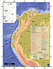 Figure 1
The Andes have dense population centers, concentrated mostly in elevated regions of the Venezuelan and Colombian Andes and along the Pacific coasts of Ecuador and Peru. A shared characteristic of these urban centers is their proximity to seismically active faults. For example, the cities of Bucaramanga and Santiago de Guayaquil lie adjacent to the Bucaramanga and Guayaquil-Algeciras faults, and major cities such as Lima are above an active subduction zone. Earthquake hazards are not limited to the well-described subduction zone settings—devastating earthquakes occur in continental settings where active structures are often smaller but shallower and close to population centers (e.g., England and Jackson, 2011); the 2008 and 2010 earthquakes in New Zealand and China, respectively (e.g., Robinson et al., 2011), provide recent examples. To achieve the goal of understanding the distribution and kinematics of active faults, digital archives of active structures are being compiled worldwide. Attention has been paid to the Andes (e.g., Paris et al., 2000; Costa et al., 2006), and similar databases have been made for other orogens (e.g., Styron et al., 2010) and the western United States (USGS, 2006). These databases are useful for understanding seismic hazard and the dynamic mechanisms driving deformation.
We present a publicly available database, “Active Tectonics of the Andes” (ATA v.1.0), comprising over 400 active faults from northeast Venezuela to southern Peru. These structures were mapped from our own field observations, interpretation of geologic maps, topography, remote sensing data, and earthquake seismicity from national databases of the geological surveys of Venezuela, Colombia, Ecuador, and Peru (FUNVISIS, INGEOMINAS, EPN, and IGP, respectively [see references]). Fault names and kinematics are compiled from academic journals and regional compilations. Faults were mapped at scales ranging from ~1:1,000,000 to 1:100,000, depending on the scale of the structure, the quality of remote sensing imagery, and accounting for uncertainties in fault kinematics. ATA v.1.0 is suitable for displaying with most GIS packages (e.g., ArcGIS), the Generic Mapping Tools (Wessel and Smith, 1998), and Google Earth. Where available, millennial and longer-term slip rates and references are included as metadata in .shp and .kml formats. User input is encouraged to contribute to or refine the database.
Tectonic Setting
Slip partitioning in the northern Andes is highly dependent on the plate boundary configuration relative to the surface velocity field. Where convergence is orthogonal, we generally expect to observe pure shear deformation (in map view), whereas in regions of oblique convergence, an element of simple shear deformation is expected. Orthogonal convergence between the Nazca and South American plates is restricted to the region near 5°S latitude, whereas the Caribbean plate is underthrusting obliquely below northern South America (Fig. 1). To the north and south, rapid increases in convergence obliquity lead to the development of significant trench-parallel strike-slip faults (Dewey and Lamb, 1992) (Fig. 1). Thrust faults bound the forearc and sub-Andean zones, though their shortening rates and histories are largely unknown. The northern tectonic domain is characterized by the presence of abundant volcanism and low magnitude earthquakes, whereas volcanism is virtually absent south of the Carnegie Ridge; seismic events are larger, but less frequent (Fig. DR1, GSA supplemental data repository 1 ).
1 GSA Data Repository item 2012274, Figure DR1, is online. You can also request a copy from GSA Today, P.O. Box 9140, Boulder, CO 80301-9140, USA; .
Northern Andean Domain (~5°S–12°N)
North of the Talara bend, slip partitioning occurs along active thrust and dextral faults. The longest dextral fault in this area is the Guayaquil-Algeciras fault system (Fig. 1A), extending ~2000 km from central Ecuador to southern Colombia. The Guayaquil-Algeciras fault is segmented based on changes in fault strike, forming contractional structures along restraining bends. The southernmost segment is the Guayaquil-Pallatanga fault, which is dominantly right-slip, but close to the trench it is associated with normal faulting in the Gulf of Guayaquil. Estimated extension rates for the Gulf of Guayaquil range from 2.5 to 9 mm/yr (Lavenu, 2006), with a right-lateral component estimated to be 3.8 ± 0.9 mm/yr over the past 1.4 Myr (Lavenu et al., 1995). The La Victoria–Pisayambo segment is thrust dominated and occurs along the central fault segment located in the Ecuadorian hinterland (Fig. 1). Here, the Guayaquil-Algeciras fault has a slip rate of 1.4 ± 0.3 mm/yr (Lavenu et al., 1995). The northern strand of the Guayaquil-Algeciras fault system is defined by the Chingual–La Sofia right-slip fault, also known as the Cayambe-Afiladores-Sibundoy fault, with slip rates between 7 ± 3 mm/yr over the past 37 kyr (Ego et al., 1996) and a Quaternary average of 11.9 ± 7 mm/yr (Tibaldi et al., 2007). The fault system continues to the northeast, where east-directed range-bounding thrust faults occur along the easternmost Colombian Andes (Fig. 1). In Colombia, the Guayaquil-Algeciras fault system is described in detail by Velandia et al. (2005), where recently active structures include synthetic and antithetic Riedel faults, pull apart basins, and releasing bends. Based on the maximum age of Quaternary offset geomorphic features, the minimum slip rate for the Guayaquil-Algeciras fault system in Colombia is ~1.5 mm/yr (Chorowicz et al., 1996). Potentially, the fault system merges with the easternmost frontal thrust system of Colombia (i.e., the Cusiana-Yopal fault system), although a direct kinematic linkage is not documented (Costa et al., 2006; Velandia et al., 2005). However, the kinematic compatibility between the Guayaquil-Algeciras fault system and the Cusiana-Yopal fault system suggests the two are interacting. Furthermore, observations from seismic reflection profiles also suggest that active deformation is transferred into the active foreland basin (Mora et al., 2010).
Other first-order fault systems of the Colombian Andes include the northwest-striking Santa Marta–Bucaramanga fault system, which is a left-slip fault system, ~500 km in length (Fig. 1). Its southeastern tip is located near the central portion of the eastern Cordillera and sits above the Bucaramanga seismic nest. The Santa Marta–Bucaramanga fault system is thought to be the surface response to slab collision (Taboada et al., 2000). Here, it splays in map pattern into an imbricate fan and links with northeast-striking thrust faults (Fig. 1). To the northwest, the Santa Marta–Bucaramanga fault system terminates at the northwestern corner of the Sierra Nevada de Santa Marta. Slip rate estimates for this fault system range from 0.2 mm/yr, based on maximum ages of Quaternary offset features (Paris et al., 2000), to 5 and 15 mm/yr, based on paleoseismological studies close to its northern end (Diederix et al., 2009; Idárraga-García and Romero, 2010). This fault system has a 6 ± 2 mm/yr interseismic rate based on elastic dislocation modeling of GPS data (Trenkamp et al., 2002).
In the region of the Maracaibo block, the Merida Andes do not represent a typical Andean-type convergent margin—there is no active volcanism or deep earthquake seismicity, and the location and extent of the subducting slab remains uncertain (Fig. 1A; Fig. DR1 [see footnote 1]) (van der Hilst and Mann, 1994; Bezada et al, 2010). Active slip appears to be partitioned mainly between east-striking right-slip faults across Venezuela and onto south-directed thrust systems associated with the South Merida thrust system. A significant structure of this kinematic domain is the right-slip Boconó–Ancon–El Pilar fault system, which is ~1,600 km in length. The Boconó–Ancon–El Pilar fault system is east-striking and transfers slip from the subduction zone associated with the eastern Caribbean plate boundary. This fault system continues west and curves to the south where it terminates in eastern Colombia, feeding slip into a southeast-directed imbricate thrust system (Fig. 1A). Slip rate estimates for different segments of the fault yield a Quaternary average of 10 mm/yr (Audemard et al., 2000). Shortening rates along the south-verging thrusts of the Merida Andes remain unknown, as are rates of normal faulting in eastern Venezuela. Northwest of the Boconó–Ancon–El Pilar fault system is the Oca-Ancon fault system, a right lateral fault extending more than 400 km from Venezuela to northern Colombia, where it bounds the northern margin of the Santa Marta massif, forming a v-shaped conjugate fault system with the Santa Marta–Bucaramanga fault (Trenkamp et al., 2002; Acosta et al., 2007; Costa et al., 2006). Based on paleoseismological analysis, the Oca-Ancon fault system has a slip rate of ~2 mm/yr (Audemard, 1996).
Central Andean Domain (~5°S–15°S)
The convergent margin of the Peruvian Andes is characterized by oblique subduction of the Nazca plate (McNulty et al., 1998), as well as the subduction of the Carnegie Ridge, Mendaña Fault Zone, and Nazca Ridge at the northern, central, and southern segments, with an inferred flat-slab geometry for the Nazca plate (Gutscher et al., 2000). The absence of seismicity above the subducted Carnegie ridge and Mendaña Fault zone, combined with the absence of volcanism (Figs. 1A and 2), is distinctive for this segment of the Peruvian Andes. Deformation in the Sub-Andean zone is accommodated by east-northeast–directed thrusting in the eastern foothills and interacting left-lateral and normal faults within the Andean highlands (Fig. 1A).
|
GPS velocity vectors for the northern Andes from Kendrick et al., 2001 (red); Pérez et al., 2001 (green); Trenkamp et al., 2002 (black); Pérez et al., 2011 (blue); and the USGS, 2012 (purple). Structural contours for the Nazca slab determined from earthquake hypocenters and modified after Gutscher et al., 2000. |
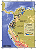 Figure 2
Active thrust faults and folds are common along the sub-Andean zone of Peru. Plio-Pleistocene sediments are deformed by the west directed Campanquiz thrust on the eastern margin of the Santiago Basin (Fig. 1A). Thrust faults are dominantly north-striking with lengths between 100 and 600 km, striking perpendicular to the main geodetic shortening direction. South of 5°S, the Andes change to a northwest trend. Here, left-lateral faults cut obliquely across the Andes from the retroarc foreland basin toward the Cordillera Blanca to the west. Estimated rates of strike-slip faulting range between 2–3 mm/yr over the past 2 Myr (Sébrier et al., 1985). The Cordillera Blanca is a west-southwest–dipping detachment (normal) fault located in the Peru highlands. It is thought to represent either orogenic collapse (McNulty et al., 1998; Giovanni et al., 2010) or subduction of buoyant aseismic ridge-related extension (McNulty and Farber, 2002). Normal faults are also located along the Peru coast, where offset marine terraces indicate slip rates of ~0.1 mm/yr. Here, normal faulting accommodates coseismic subsidence in the landward part of the thrust wedge during strain release associated with subduction zone thrust events (Saillard et al., 2011).
The ATA database is useful for synthesizing the regional tectonic framework by comparing the distribution and kinematics of active faulting to the GPS velocity field (Fig. 2). We compiled GPS velocities from a variety of sources (Kendrick et al., 2001; Pérez et al., 2001, 2011; Trenkamp et al., 2002; USGS, 2011), referenced to stable South America in the ITRF2000 reference frame. The velocities decrease eastward across the entire width of the orogen, consistent with previous studies using elastic dislocation modeling (e.g., Trenkamp et al., 2002), showing that convergence is primarily accommodated across the locked subduction megathrust with minor deformation accommodated on upper plate faults.
As previously described, oblique convergence leads to slip partitioning into trench-normal thrusting along the trench and sub-Andes and trench-parallel strike-slip faulting in the orogen interior. The GPS velocities are decomposed into their trench-normal and trench-parallel components (Fig. 3); these surface velocities reflect end-member components of pure dip-slip faulting on thrust faults and horizontal motion along the strike-slip faults. The true degree of partitioning is not recoverable directly from the interseismic strain field, but earthquake focal mechanisms are consistent with active slip partitioning. Unlike previous studies, we consider the entire Andean margin north of southern Peru. In this view, the variation in convergence obliquity due to the changing trend of the margin causes a large increase in the trench-parallel component of the velocity field, with the highest gradient of the velocity in southern Ecuador and northern Peru (Fig. 1B). The large trench-parallel velocity gradient at the Talara bend suggests that trench-parallel extension is localized here, as indicated by northwest-striking normal faults at the Gulf of Guayaquil, where Pliocene sediments in the extensional basins exceed 5 km in thickness (Lavenu et al., 1995). We suggest the trench-parallel component of basal shear stresses acting on the North Andean block causes it to move in an arc-parallel direction due to oblique subduction (Fig. 1B), analogous to the Sumatran arc (Fitch, 1972).
|
(A) Trench-parallel component of GPS velocities. Swath profiles span the trench and 200 km inboard (Swath 1), from 200 to 400 km (Swath 2), and from 400 to 800 km (Swath 3) inboard. Numbers denote the different domains defined for the GPS analysis: 1—Venezuela; 2—Colombia; 3—Ecuador; 4 and 5—Peru. (B) Trench-parallel and normal components plotted as a function of latitude. Positive trench-parallel velocities are defined as counterclockwise. Note the opposing sense of motion in trench-parallel velocities around 5°S at the Talara Bend. Red and blue lines are the approximate trends of trench parallel and normal components in the different domains. Components from Swath 3 are not shown for clarity. (C), (D), and (E) are the trench normal and parallel projections of the velocity components for each domain. See (A) for profile locations. CASM station from Kendrick et al., 2001, was excluded from the analysis. |
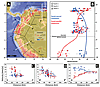 Figure 3
Although the northern Andes display a gross north-south symmetry at 5°S, differences between the Ecuadoran-Colombian and Peruvian Andes exist, observed both in the GPS velocity field and in the distribution of active faults (Figs. 1 and 3). North of 5°S, the across-strike gradient in trench-parallel velocity is large, at 1–2 cm/yr of dextral shear. In the south, the trench-parallel velocity gradient is consistent with sinistral shear at <1 cm/yr (Fig. 3). Similarly, trench-parallel strike-slip faulting in Ecuador and Colombia is well-developed, with faults extending for hundreds of kilometers and Holocene slip rates near 1 cm/yr (e.g., Guayaquil-Algeciras fault system; Lavenu et al., 1995; Tibaldi et al., 2007). Peruvian trench-parallel strike-slip faults, only observed in central and southern Peru, are shorter along-strike, suggesting less displace-ment magnitude (e.g., Cowie and Scholz, 1992) and possibly lower slip rates, but the rates are currently unknown. The differences may result in part from the different boundary conditions on the far end of mobile blocks. The north Andes override the Caribbean plate, resembling a subduction boundary in some respects, while motion of the southern coastal block is constrained by the Altiplano and northward-moving slivers south of the bend (Wang et al., 2007). Slip partitioning in Venezuela is largely reflected by right-slip faulting with slip rates between 3–17 mm/yr (Fig. 3), which is in agreement with slip rates derived from seismological analysis of 8–10 mm/yr for the Boconó Fault (Audemard et al., 2000). In comparison, north-south shortening plays a more minor role but is still significant, with shortening rates of ~2 mm/yr (Fig. 3).
Active Tectonics of the Andes Database
The ATA v.1.0 database may be downloaded here. For additions or modifications to the database, please contact the authors.
Conclusions
The Ecuadoran-Colombian and Peruvian Andes display similar deformation styles, mirrored across latitude ~5°S. Although a wide variety of factors, such as rheology and mantle dynamics, exert control on deformation (e.g., Isacks, 1988), which were not taken into account in this analysis, the observed slip partitioning is largely controlled by the local convergence velocity and degree of convergence obliquity. In the north, convergence is highly oblique, and slip partitioning is expressed as trench-normal thrusting and rapid and well-developed trench-parallel right-slip faulting, as shown in the upper part of Figure 3B. This region is also characterized by abundant, but low-magnitude, earthquakes (Fig. DR1 [see footnote 1]) and active volcanism between 5°S and 7°N, where the subducting slab is inferred to dip ~30° (Gutscher et al., 2000) (Fig. 2). The subduction geometry is thought to change near the active arc collision with the Chocó-Panamá block, where flat-slab subduction shifts volcanism to eastern Colombia (Figs. 1 and 2).
Large gradients in trench-parallel motion may cause extension in the Gulf of Guayaquil. To the south, in northern Peru, convergence obliquity is relatively low, and trench-parallel left-slip faulting is not observed. However, the trench-parallel component of the surface velocity field increases to the south, commensurate with increasing convergence obliquity. Pure shear deformation of the central Andes is expressed as active east-directed shortening and crustal thickening, while strike-slip faulting and eastward transport occurs to the north. Right-slip faulting is characteristic of the Merida Andes, accommodating the eastward motion of the Caribbean plate and the limited coupling across the plate boundary between South America and the Caribbean (Fig. 1B).
Acknowledgments
Support for this work is through a collaborative grant between Ecopetrol-ICP project “Cronología de la deformación en las Cuencas Subandinas” and the University of Kansas. We thank Jeffrey Freymueller for valuable comments and discussions that improved and clarified our ideas. Comments and suggestions from two anonymous reviewers also improved this paper.
REFERENCES CITED
- Acosta, J., Velandia, F., Osorio, J., Lonergan, L., and Mora, H., 2007, Strike-slip deformation within the Colombian Andes, in Ries, A.C., Butler, R.W.H., and Graham, R.H., eds., Deformation of the Continental Crust: The Legacy of Mike Coward: London, Geological Society Special Publication 272, p. 303–319.
- Audemard M., F.A., 1996, Paleoseismicity studies on the Oca-Ancón fault system, northwestern Venezuela: Tectonophysics, v. 259, no. 1–3, p. 67–80.
- Audemard M., F.A., Machette, M., Cox, J., Dart, R., and Haller, K., 2000, Map and Database of Quaternary Faults and Folds in Venezuela and its Offshore Regions: USGS Open-File Report 00-0018, http://pubs.usgs.gov/of/2000/ofr-00-0018/ (last accessed 31 July 2012).
- Bezada, M., Magnani, M., Zelt, C., Schmitz, M., and Levander, A., 2010, The Caribbean–South American plate boundary at 65°W: Results from wide-angle seismic data: Journal of Geophysical Research, v. 115, B08402, doi: 10.1029/2009JB007070.
- Chorowicz, J., Chotin, P., and Guillande, R., 1996, The Garzon fault: Active southwestern boundary of the Caribbean plate in Colombia: Geologische Rundschau, v. 85, no. 1, p. 172–179.
- Costa, C., Audemard, F., Bezerra, H., Lavenu, A., Machette, M., and Paris, G., 2006, An overview of the main Quaternary deformation of South America: Revista de la Asociación Geológica Argentina, v. 61, no. 4, p. 461–479.
- Cowie, P.A., and Scholz, C.H., 1992, Displacement-length scaling relationship for faults: Data synthesis and discussion: Journal of Structural Geology, v. 14, no. 10, p. 1149–1156.
- Dalmayrac, B., and Molnar, P., 1981, Parallel thrust and normal faulting in Peru and constraints on the state of stress: Earth and Planetary Science Letters, v. 55, no. 3, p. 473–481.
- Dewey, J., and Lamb, S., 1992, Active tectonics of the Andes: Tectonophysics, v. 205, no. 1–3, p. 79–95.
- Diederix, H., Hernandez, C., Torres, E., Osorio, J.A., and Botero, P., 2009, Resultados preliminares del primer estudio paleosismológico a lo largo de la Falla de Bucaramanga: Colombia, XII Congreso Colombiano de Geología, v. 1.
- Ego, F., Sébrier, M., Lavenu, A., Yepes, H., and Egues, A., 1996, Quaternary state of stress in the Northern Andes and the restraining bend model for the Ecuadorian Andes: Tectonophysics, v. 259, no. 1–3, p. 101–116.
- England, P., and Jackson, J., 2011, Uncharted seismic risk: Nature Geoscience, v. 4, no. 6, p. 348–349.
- EPN, 2010, Catálogo de sismicidad 1990–2010: Instituto Geofísico Escuela Politécnica Nacional, Ecuador, http://www.igepn.edu.ec (last accessed 31 July 2012).
- Farris, D.W., Jaramillo, C., Bayona, G., Restrepo-Moreno, S.A., Montes, C., Cardona, A., Mora, A., Speakman, R.J., Glascock, M.D., and Valencia, V., 2011, Fracturing of the Panamanian Isthmus during initial collision with South America: Geology, v. 39, p. 1007–1010, doi: 10.1130/G32237.1.
- Fitch, T.J., 1972, Plate convergence, transcurrent faults, and internal deformation adjacent to Southeast Asia and the western Pacific: Journal of Geophysical Research, v. 77, no. 23, p. 4432–4460.
- FUNVISIS, 2011, Catálogo de sismicidad 2007–2011: Sismológicas, Fundación Venezolana de Investigaciones Sismológicas, http://www.funvisis.gob.ve (last accessed 31 July 2012).
- Giovanni, M.K., Horton, B.K., Garzione, C.N., McNulty, B., and Grove, M., 2010, Extensional basin evolution in the Cordillera Blanca, Peru: Stratigraphic and isotopic records of detachment faulting and orogenic collapse in the Andean hinterland: Tectonics, v. 29, no. 6, TC6007, doi: 10.1029/2010TC002666.
- Gutscher, M.A., Spakman, W., Bijwaard, H., and Engdahl, E.R., 2000, Geodynamics of flat subduction: Seismicity and tomographic constraints from the Andean margin: Tectonics, v. 19, no. 5, p. 814–833, doi: 10.1029/1999TC001152.
- Idárraga-García, J., and Romero, J., 2010, Neotectonic study of the Santa Marta Fault System, Western foothills of the Sierra Nevada de Santa Marta, Colombia: Journal of South American Earth Sciences, v. 29, no. 4, p. 849–860.
- IGP, 2005, Catálogo sísmico Nacional 1985–2005: Instituto Geofísico de Perú, http://www.igp.gob.pe (last accessed 31 July 2012).
- INGEOMINAS, 2010, Catálogo sísmico nacional, 1993–2010: Minería, Servicio Geológico Columbiano, http://www.ingeominas.gov.co (last accessed 31 July 2012).
- Isacks, B.L., 1988, Uplift of the central Andean plateau and bending of the Bolivian orocline: Journal of Geophysical Research, v. 93, no. B4, p. 3211–3231.
- Kendrick, E., Bevis, M., Smalley, R., and Brooks, B., 2001, An integrated crustal velocity field for the central Andes: Geochemistry, Geophysics, Geosystems, v. 2, no. 11, p. 1066.
- Lavenu, A., 2006, Neotectónica de los Andes entre 1 N y 47 S (Ecuador, Bolivia y Chile): Una revisión: Revista de la Asociación Geológica Argentina, v. 61, no. 4, p. 504–524.
- Lavenu, A., Winter, T., and Dávila, F., 1995, A Pliocene-Quaternary compressional basin in the Interandean Depression, Central Ecuador: Geophysical Journal International, v. 121, no. 1, p. 279–300.
- McNulty, B., and Farber, D., 2002, Active detachment faulting above the Peruvian flat slab: Geology, v. 30, p. 567–570, doi: 10.1130/0091-7613(2002)030<0567:ADFATP>2.0.CO;2.
- McNulty, B.A., Farber, D.L., Wallace, G.S., Lopez, R., and Palacios, O., 1998, Role of plate kinematics and plate-slip-vector partitioning in continental magmatic arcs: Evidence from the Cordillera Blanca, Peru: Geology, v. 26, p. 827–830.
- Mora, A., Parra, M., Strecker, M.R., Sobel, E.R., Zeilinger, G., Jaramillo, C., Da Silva, S.F., and Blanco, M., 2010, The eastern foothills of the Eastern Cordillera of Colombia: An example of multiple factors controlling structural styles and active tectonics: GSA Bulletin, v. 122, p. 1846–1864, doi: 10.1130/B30033.1.
- Paris, G., Machette, M.N., Dart, R.L., and Haller, K.M., 2000, Map and database of Quaternary faults and folds in Colombia and its offshore regions: USGS Open-File Report 00-0284, 60 p.
- Pérez, O.J., Bilham, R., Bendick, R., Velandia, J.R., Hernández, N., Moncayo, C., Hoyer, M., and Kozuch, M., 2001, Velocity field across the southern Caribbean plate boundary and estimates of Caribbean/South-American plate motion using GPS geodesy 1994–2000 (Paper 2001GL013183): Geophysical Research Letters, v. 28, no. 15, p. 2987–2990.
- Pérez, O.J., Bilham, R., Sequera, M., Molina, L., Gavotti, P., Moncayo, C., Rodríguez, C., Guzmán, M., Codallo, H., and Velandia, R., 2011, Campo de velocidades GPS en el occidente de Venezuela: Componente lateral derecha asociada a la Falla de Boconó y componente convergente perpendicular a Los Andes: Interciencia, no. 1, p. 39–44.
- Pindell, J., Kennan, L., Maresch, W.V., Stanek, K., Draper, G., and Higgs, R., 2005, Plate-kinematics and crustal dynamics of circum-Caribbean arc-continent interactions: Tectonic controls on basin development in Proto-Caribbean margins, in Avé Lallemant, H.G., and Sisson, V.B., eds., Caribbean–South American Plate Interactions, Venezuela: Geological Society of America Special Paper 394, p. 7.
- Robinson, R., Van Dissen, R., and Litchfield, N., 2011, Using synthetic seismicity to evaluate seismic hazard in the Wellington region, New Zealand: Geophysical Journal International, v. 187, p. 510–528, doi: 10.1111/j.1365-246X.2011.05161.x.
- Saillard, M., Hall, S., Audin, L., Farber, D., Regard, V., and Hérail, G., 2011, Andean coastal uplift and active tectonics in southern Peru: 10Be surface exposure dating of differentially uplifted marine terrace sequences (San Juan de Marcona, ~15.4°S): Geomorphology, v. 128, p. 178–190, doi: 10.1016/j.geomorph.2011.01.004.
- Sébrier, M., Mercier, J.L., Mégard, F., Laubacher, G., and Carey-Gailhardis, E., 1985, Quaternary normal and reverse faulting and the state of stress in the central Andes of south Peru: Tectonics, v. 4, no. 7, p. 739–780.
- Styron, R., Taylor, M., and Okoronkwo, M., 2010, Database of active structures from the Indo-Asian Collision: Eos (Transactions of the American Geophysical Union), v. 91, no. 20, p. 181, doi: 10.1029/2010EO200001.
- Taboada, A., Rivera, L.A., Fuenzalida, A., Cisternas, A., Philip, H., Bijwaard, H., Olaya, J., and Rivera, C., 2000, Geodynamics of the northern Andes: Subductions and intracontinental deformation (Colombia): Tectonics, v. 19, no. 5, p. 787–813.
- Tibaldi, A., Rovida, A., and Corazzato, C., 2007, Late Quaternary kinematics, slip-rate and segmentation of a major Cordillera-parallel transcurrent fault: The Cayambe-Afiladores-Sibundoy system, NW South America: Journal of Structural Geology, v. 29, no. 4, p. 664–680.
- Trenkamp, R., Kellogg, J.N., Freymueller, J.T., and Mora, H.P., 2002, Wide plate margin deformation, southern Central America and northwestern South America, CASA GPS observations: Journal of South American Earth Sciences, v. 15, no. 2, p. 157–171.
- USGS, 2006, Quaternary fault and fold database for the United States: USGS, http://earthquake.usgs.gov/regional/qfaults/ (last accessed 31 July 2012).
- USGS, 2012, GPS Velocities Ecuador: USGS, http://earthquake.usgs.gov/monitoring/gps/Ecuador/velocities/ (last accessed 31 July 2012).
- van der Hilst, R., and Mann, P., 1994, Tectonic implications of tomographic images of subducted lithosphere beneath northwestern South America: Geology, v. 22, no. 5, p. 451–454.
- Velandia, F., Acosta, J., Terraza, R., and Villegas, H., 2005, The current tectonic motion of the Northern Andes along the Algeciras Fault System in SW Colombia: Tectonophysics, v. 399, no. 1, p. 313–329.
- Wang, K., Hu, Y., Bevis, M., Kendrick, E., Smalley Jr., R., Vargas, R.B., and Lauría, E., 2007, Crustal motion in the zone of the 1960 Chile earthquake: Detangling earthquake-cycle deformation and forearc-sliver translation: Geochemistry Geophysics Geosystems, v. 8, no. 10, Q10010.
- Wessel, P., and Smith, W.H.F., 1998, New, improved version of Generic Mapping Tools released: Eos (Transactions of the American Geophysical Union), v. 79, p. 579.