
Full Text View
Volume 21 Issue 9 (September 2011)
GSA Today
![]()
Article, pp. 5-7 | Abstract | PDF (468KB)
Learning from failure: The SPREE Mid-Continent Rift Experiment
| Table of Contents |
|---|
Search GoogleScholar for
Search GSA Today |
Special 2011 Annual Meeting–Themed Science Article Section
In a departure from GSA Todays usual single lead science article format, the following four articles are meant to familiarize you with the span of geologic time represented in the Upper Midwest and the expertise of its geoscience community as we prepare to assemble at the Annual Meeting in Minneapolis. These articles also emphasize the critical role geologists are being asked to play in a society that is increasingly focused on sustainable resource use and the long-term resilience of the planet.
The first two papers treat geologic events from opposite ends of the timeline as a controlled experiment that can be studied to help understand, and thereby forecast, system responses. The latter two speak directly to our role in society.
The EarthScope USArray is currently deployed in Minnesota. Seth Stein and colleagues describe how the information coming in regarding the failed, 1.1-Ga midcontinent rift, frozen in time, will provide a way to test the two leading theories about the fundamental cause of rifting.
Next, Karen Gran and colleagues describe Holocene valley evolution. A well-constrained downcutting event is driving continuing adjustment on tributaries to the Minnesota River, the history of which has a strong influence on modern sediment loads and direct resource-management implications.
Ken Bradbury and Tony Runkel, geologists with two state surveys, partnered up for the third article, which examines how the mechanical behavior of Paleozoic rocks affects groundwater flow systems. This information is critical for sustainable groundwater use in the face of challenges ranging from the presence of live viruses deep beneath Madison, Wisconsin, USA, to evolving cones of depression that change hydraulic gradients.
Finally, Cathy Manduca introduces readers to the process of producing an educated citizenry (and a well-prepared geoscience community) that understands the ways that Earth and society are linked. The article also illustrates the need to act collectively to share experiences, develop them into classroom activities, and accurately diagnose student challenges.
Carrie Jennings, Minnesota Geological Survey
Vice Chair, 2011 Annual Meeting Organizing Committee
Engineers have long realized that much can be learned about how complicated systems like aircraft or nuclear reactors really—as opposed to ideally—work by studying their failures. The same is likely to be true for the rifting phase of the Wilson cycle, in which continents drift apart to form new oceans that may grow to the size of the Atlantic and Pacific before closing and vanishing.
However, many continental rifts fail to develop into seafloor spreading centers. Such failed rifts become an important part of the fabric of the continents.
Rifting—successful or failed—shapes the continents and has crucial effects for society. It provides conditions for the deposition of hydrocarbons and other mineral resources. Moreover, some earthquakes within generally stable continents occur on failed rifts.
Manuscript received 27 Feb. 2011; accepted 17 Apr. 2011.
DOI: 10.1130/G120A.1
*E-mail:
Despite its importance, much remains to be learned about how and why continental rifting occurs. Two end-member models have been discussed for many years (Şengör and Burke, 1978). In one, “active” rifting is a response to melting in the underlying asthenosphere or deeper mantle as a result of mantle plumes or shallower thermal or compositional anomalies, as commonly proposed for the East African Rift (Ebinger and Sleep, 1998). In the other, rifting is a “passive” response to stresses transmitted within the lithosphere, as appears to be the case along the Baikal Rift where the Amurian plate diverges from Eurasia (Calais et al., 2003). It is consequently unclear whether large-scale magmatism is a cause or effect of rifting, and the associated mantle dynamics remains unresolved. Similarly, the roles of shallow and deep crustal faults in the extension are debated.
Most of our knowledge about ancient rifting comes from studying continental rifting occurring today or passive continental margins remaining from successful rifts. An alternative is to study failed rifts preserved in continental interiors, such as North America’s Mid-Continent Rift System (Fig. 1). This system evolved at ca. 1.1 Ga during a rifting event recorded by volcanic, plutonic, and sedimentary rocks (Hinze et al., 1997).
|
Location and general structure of the Midcontinent Rift. |
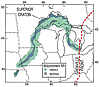 Figure 1
The 2000-km-long Mid-Continent Rift System, which is comparable in length to the present East African and Baikal rifts, has two major arms meeting in the Lake Superior region. One extends southwestward at least as far as Kansas, and the other extends southeastward through Michigan. These arms are identified using the large gravity and magnetic anomalies resulting from dense and highly magnetic mafic igneous rocks. They are largely covered by Paleozoic sediments but outcrop near Lake Superior and can be followed further south in drill cores. Figure 1 thus shows the rift system’s minimum extent.
Active source seismic studies across Lake Superior (Cannon et al., 1989) show that the crust was thinned to about one-fourth of its original thickness by extension, the basin was filled with extrusive volcanics and sediments, and the lower crust was subsequently thickened by volcanic underplating. This rethickening process has now been identified elsewhere, as at the Baikal rift (Thybo and Nielson, 2009).
However, fundamental questions remain unresolved.
First, how did it start? Petrologic and geochemical models favor the formation of the Mid-Continent Rift System by active rifting over a mantle plume (Nicolson et al., 1997). In such scenarios, the two arms are analogous to today’s East African rift–Red Sea–Gulf of Aden system that is splitting Africa into three plates. The Nipigon volcanic region to the north might then have been a third arm. Testing this hypothesis is challenging because the extension is dated via the volcanism, making it difficult to establish relative chronology. Alternatively, many tectonic models view the rift as having formed as part of the Grenville orogeny, the series of 1.3–0.9 Ga tectonic events to the east associated with the assembly of Rodinia (Whitmeyer and Karlstrom, 2007). In such interpretations, northwest-directed convergence at the southern margin of Laurentia (North America) caused extension and magmatism to the northwest, including formation of the Mid-Continent Rift System. This scenario could be similar to the way the Baikal rift results from the Himalayan collision. If so, how did rifting occur? What controlled its geometry?
Second, how did rifting proceed? How did the geometry and history of rifting differ between and along the two arms? Did the western arm have more extension and volcanism, as suggested by the gravity data, or does the difference reflect the rift’s present depth? How did the microplate bordered by the rift arms (Chase and Gilmer, 1973; Hauser, 1996) evolve? How far southward do the arms extend and why? What controls the division of the rift into distinct segments? Are these structurally different? What was the sequence of extension, volcanism, and subsidence in each? How did crustal thinning followed by intrusion deepen the Moho?
Third, why and how did it fail? Was it unable to extend along strike to split the continent? Was it unable to sustain itself? Did changing far-field stresses as the Grenville orogeny progressed cause compression that slowed and stopped the extension and then inverted the normal faults, producing thrust faulting (Cannon, 1994)? Why is the western arm close to the surface, whereas the eastern arm is deeply buried within the Michigan Basin? Did the Michigan arm play a role in the later (600 Ma) formation of the Michigan Basin?
Resolving these questions will require a range of investigations using different techniques. Among these is EarthScope’s USArray program, which uses recent advances in seismological instrumentation and analysis methods to study North America’s deep crust and mantle. As part of Earthscope, we are conducting a project named SPREE (Superior Province Rifting Earthscope Experiment).
SPREE uses Earthscope’s broadband Flexarray seismometers in two ways (Fig. 2). One extends the Transportable Array, now moving across the U.S., into Canada, where the Mid-Continent Rift System follows or cuts the edge of the Archean Superior Craton. A second uses seismometers deployed along and across the rift in the U.S. (Fig. 3). Records of distant earthquakes will be analyzed to provide multiscale 3-D images of the structure of the crust and mantle beneath the rift system and its surroundings. The images will then show details of the transition from the Archean shield of northern Minnesota to the Mid-Continent Rift and then to the Proterozoic orogenic rocks of Wisconsin, and allow comparisons of the velocity structure to the gravity and magnetic anomalies.
|
Gravity anomaly map of the Midcontinent Rift region, showing permanent, transportable array, and flexible array seismic stations being used in SPREE. |
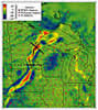 Figure 2
|
Emily Wolin and Jessica Lodewyk installing a SPREE station in northern Wisconsin. |
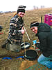 Figure 3
The results should provide new constraints on the rifting event and its cessation. Although its thermal signature should be long gone, the role of the mantle could be reflected in velocity or density anomalies associated with melt depletion and seismic anisotropy. The depth extent of depleted mantle beneath the rift basalts will help constrain the mantle temperature structure at the time of rifting and the role of melting in the rifting. Velocity structure across the rift will constrain the across-strike extent of crustal and lithospheric thinning. The change in velocity structure across the rift’s ends should give insight into what controlled its along-strike geometry. Because the rift system is currently seismically inactive, in contrast to some younger failed rifts like the Reelfoot Rift, comparison of seismic velocities may give insight as to how the crust “heals” mechanically.
These SPREE results will contribute to the emerging discipline of “comparative riftology” (Ziegler and Cloetingh, 2004), in which data from present, successful past, and failed rifts worldwide are being combined to give an integrated view of these complex processes.
REFERENCES CITED
- Calais, E., Vergnolle, M., Sankov, V., Lukhnev, A., Miroshnitchenko, A., Amarjargal, S., and Déverchère, J., 2003, GPS measurements of crustal deformation in the Baikal-Mongolia area: Journal of Geophysical Research, v. 108, doi: 10.1029/2002JB002373.
- Cannon, W., 1994, Closing of the Midcontinent Rift—A far-field effect of Grenvillian compression: Geology, v. 22, p. 155–158, doi: 10.1130/0091-7613(1994)022<0155:COTMRA>2.3.CO;2.
- Cannon, W.F., Green, A.G, Hutchinson, D.R., Lee, M., Milkereit, B., Behrendt, J.C., Halls, H.C., Green, J.C.. Dickas, A.B., Morey, G.B., Sutcliffe, R., and Spencer, C., 1989, The North American Midcontinent Rift beneath Lake Superior from GLIMPCE seismic reflection profiling: Tectonics, v. 8, p. 305–332.
- Chase, C., and Gilmer, T., 1973, Precambrian plate tectonics: the midcontinent gravity high: Earth and Planetary Science Letters, v. 21, p. 70–78.
- Ebinger, C., and Sleep, N., 1998, Cenozoic magmatism throughout east Africa resulting from impact of a single plume: Nature, v. 395, p. 788–791.
- Hauser, E., 1996, Midcontinent Rifting in a Grenville embrace, in Van Schmus, W.R., Bickford, M.E., and Turek, A., eds., Proterozoic geology of the east-central Midcontinent basement: Geological Society of America Special Paper 308, p. 67–75.
- Hinze, W.J., Allen, D.J., Braile, L.W., and Mariano, J., 1997, The Midcontinent rift system: A major Proterozoic continental rift, in Ojakangas, R.W., Dickas, A.B., and Green, J.C., eds., Middle Proterozoic to Cambrian rifting, central North America: Geological Society of America Special Paper 312, p. 7–35.
- Nicholson, S., Nicholson, S.W., Shirey, S.B., Schulz, K.J., and Green, J.C., 1997, Rift-wide correlation of 1.1 Ga Midcontinent rift system basalts: Canadian Journal of Earth Sciences, v. 34, p. 504–520.
- Şengör, A.M.C., and Burke, K., 1978, Relative timing of rifting and volcanism and its tectonic implications: Geophysical Research Letters, v. 5, p. 419–421.
- Thybo, H., and Nielson, H., 2009, Magma-compensated crustal thinning in continental rift zones: Nature, v. 457, p. 873–876.
- Whitmeyer, S., and Karlstrom, K., 2007, Tectonic model for the Proterozoic growth of North America: Geosphere, v. 3, p. 220–259.
- Ziegler, P., and Cloetingh, S., 2004, Dynamic processes controlling evolution of rift basins: Earth Science Reviews, v. 64, p. 1–50.
Erratum: The reference in this article to GSA Special Paper 308 lists W.R. Van Schmus, M.E. Bickford, and A. Turek as volume editors. This is incorrect. The volume editors for SPE308 are Ben A. van der Pluijm and Paul A. Catacosinos. GSA Today regrets this error.